Choelquoit Lake fishing map is included in Lakes and Rivers of British Columbia nautical charts folio. It is available as part of iBoating : Canada Marine & Fishing App (now supported on multiple platforms including Android, iPhone/iPad, MacBook, and Windows(tablet and phone)/PC based chartplotter. ).
With our Lake Maps App, you get all the great marine chart app features like fishing spots, along with Choelquoit Lake depth map. The fishing maps app include HD lake depth contours, along with advanced features found in Fish Finder / Gps Chart Plotter systems, turning your device into a Depth Finder. The Choelquoit Lake Navigation App provides advanced features of a Marine Chartplotter including adjusting water level offset and custom depth shading. Fishing spots and depth contours layers are available in most Lake maps. Lake navigation features include advanced instrumentation to gather wind speed direction, water temperature, water depth, and accurate GPS with AIS receivers(using NMEA over TCP/UDP). Autopilot support can be enabled during ‘Goto WayPoint’ and ‘Route Assistance’.
Now i-Boating supports Fishing Points in Choelquoit Lake.
Have more questions about the Nautical Chart App? Ask us.
Fishing Info for Choelquoit Lake
Choelquoit lake is an endorheic lake in the western Chilcotin District of the Central Interior of British Columbia, Canada, located north of Chilko Lake, west of Tatlayoko Lake, and east of Williams Lake. The lake is the largest high elevation lake in Canada without an outflow, and sits on the western edge of the Chilcotin plateau, surrounded by grasslands, pine forest, and views of the snow-capped Niut Mountains. There is a camp site on the east side of the lake. The lake lies within the title land of the Tsilhqot'in First Nation. The traditional indigenous name for the lake is Naghatalhchuẑ.
More on Wikipedia...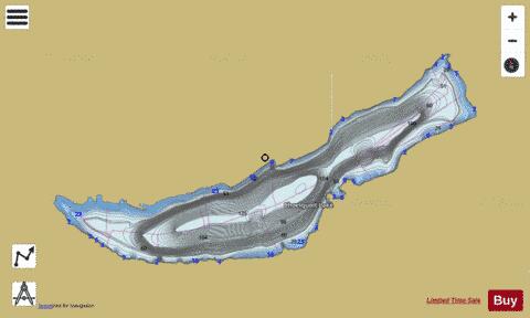
Choelquoit Lake Fishing Map Stats | |
| Title | Choelquoit Lake |
| Scale | 1:24000 |
| Districts | Cariboo |
| Area * | 2920.78 acres |
| Shoreline * | 15.44 miles |
| Min Longitude | -124.27 |
| Min Latitude | 51.69 |
| Max Longitude | -124.15 |
| Max Latitude | 51.73 |
| Edition Label 1 | |
| Edition Label 2 | |
| Edition Label 3 | |
| Id | CA_BC_choelquoit_lake_bc |
| Country | CA |
| Projection | Mercator |
| * some Stats may include nearby/connecting waterbodies | |
|