Thompson fishing map is available as part of iBoating : USA Marine & Fishing App(now supported on multiple platforms including Android, iPhone/iPad, MacBook, and Windows(tablet and phone)/PC based chartplotter.).
With our Lake Maps App, you get all the great marine chart app features like fishing spots, along with Thompson lake depth map. The fishing maps app include HD lake depth contours, along with advanced features found in Fish Finder / Gps Chart Plotter systems, turning your device into a Depth Finder. The Thompson Navigation App provides advanced features of a Marine Chartplotter including adjusting water level offset and custom depth shading. Fishing spots and depth contours layers are available in most Lake maps. Lake navigation features include advanced instrumentation to gather wind speed direction, water temperature, water depth, and accurate GPS with AIS receivers(using NMEA over TCP/UDP). Autopilot support can be enabled during ‘Goto WayPoint’ and ‘Route Assistance’.
Now i-Boating supports Fishing Points in Thompson.
Have more questions about the Nautical Chart App? Ask us.
Fishing Info for Thompson
Lake Thompson is a lake in Kingsbury County, South Dakota, United States. With an area of 16,236 acres (65.70 km2), it is one of the largest natural lakes in South Dakota. The maximum depth of the lake is 26 ft (7.9 m), and the shoreline has a length of 44.6 miles (71.8 km). The lake is located in east-central South Dakota, on the Coteau des Prairies and is within the watershed of the Vermillion River. Lake Thompson's size is highly variable. It was completely dry during the 1930s. By the early 1990s, it had grown to cover (at times) 20,000 acres (81 km2), becoming the largest natural lake in the state. The lake is the location of a state recreation area managed by the South Dakota Department of Game, Fish, and Parks which includes camping facilities. Several boat launches are also located on the lake. A popular destination for anglers, game fish in the lake include walleye, northern pike, yellow perch and sunfish. Common carp and black bullheads are also present. The area is an important habitat for fish and waterfowl, and Lake Thompson has been named a National Natural Landmark. Lake Thompson has the name of John Thompson, an early settler. Lake Thompson is near De Smet, one of the residences of author Laura Ingalls Wilder, and appears in several of her novels as one of the "Twin Lakes", along with Lake Henry.
More on Wikipedia...Popular fish species in this lake include Black bullhead, Common carp, Northern pike, Walleye and Yellow perch.
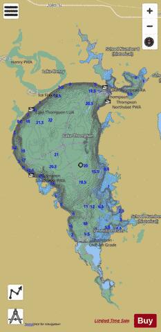
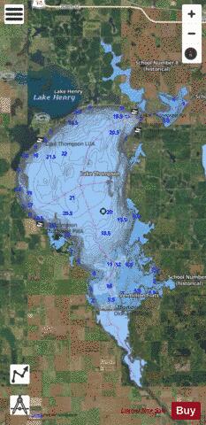
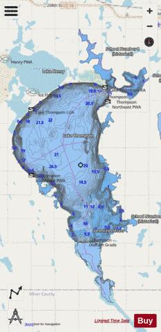
Thompson Fishing Map Stats | |
| Title | Thompson |
| Scale | 1:24000 |
| Counties | Kingsbury, Miner |
| Nearby Cities | Lake Preston, Oldham, De Smet, Erwin, Hetland, Winfred, Howard, Ramona, Carthage, Bryant |
| Area * | 14543.17 acres |
| Shoreline * | 89.89 miles |
| Min Longitude | -97.51 |
| Min Latitude | 44.19 |
| Max Longitude | -97.39 |
| Max Latitude | 44.35 |
| Edition Label 1 | |
| Edition Label 2 | |
| Edition Label 3 | |
| Id | US_SD_thompson_kingsbury_sd |
| Country | US |
| Projection | Mercator |
| * some Stats may include nearby/connecting waterbodies | |
|