Byron fishing map is available as part of iBoating : USA Marine & Fishing App(now supported on multiple platforms including Android, iPhone/iPad, MacBook, and Windows(tablet and phone)/PC based chartplotter.).
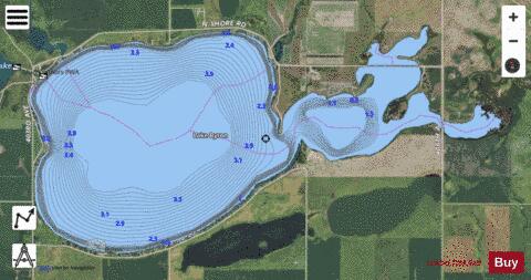
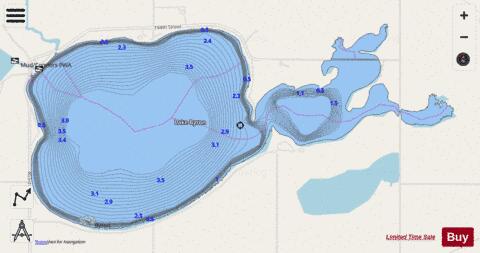
With our Lake Maps App, you get all the great marine chart app features like fishing spots, along with Byron lake depth map. The fishing maps app include HD lake depth contours, along with advanced features found in Fish Finder / Gps Chart Plotter systems, turning your device into a Depth Finder. The Byron Navigation App provides advanced features of a Marine Chartplotter including adjusting water level offset and custom depth shading. Fishing spots and depth contours layers are available in most Lake maps. Lake navigation features include advanced instrumentation to gather wind speed direction, water temperature, water depth, and accurate GPS with AIS receivers(using NMEA over TCP/UDP). Autopilot support can be enabled during ‘Goto WayPoint’ and ‘Route Assistance’.
Have more questions about the Nautical Chart App? Ask us.
Fishing Info for Byron
Lake Byron is a lake in Beadle County, South Dakota, U.S.; it is fed by Foster Creek and feeds out to the James River. The lake derives its name of Byron Pay, who stayed briefly at the lake in the 1860s and left his name carved on a tree there. The Albert S. Piper Homestead Claim Shanty is about two miles north, and the is to the northeast.
More on Wikipedia...Popular fish species in this lake include Black bullhead, Black crappie, Common carp, Northern pike, Walleye and Yellow perch.
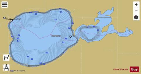
Byron Fishing Map Stats | |
| Title | Byron |
| Scale | 1:12000 |
| Counties | Beadle |
| Nearby Cities | Yale, Carpenter, Morningside, Huron, Broadland, Cavour, Hitchcock, Osceola, Iroquois, Doland |
| Area * | 1875.22 acres |
| Shoreline * | 18.54 miles |
| Min Longitude | -98.16 |
| Min Latitude | 44.55 |
| Max Longitude | -98.09 |
| Max Latitude | 44.58 |
| Edition Label 1 | |
| Edition Label 2 | |
| Edition Label 3 | |
| Id | US_SD_byron_beadle_sd |
| Country | US |
| Projection | Mercator |
| * some Stats may include nearby/connecting waterbodies | |
|