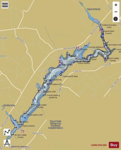
Lake Nockamixon fishing map is available as part of iBoating : USA Marine & Fishing App(now supported on multiple platforms including Android, iPhone/iPad, MacBook, and Windows(tablet and phone)/PC based chartplotter.).
With our Lake Maps App, you get all the great marine chart app features like fishing spots, along with Lake Nockamixon depth map. The fishing maps app include HD lake depth contours, along with advanced features found in Fish Finder / Gps Chart Plotter systems, turning your device into a Depth Finder. The Lake Nockamixon Navigation App provides advanced features of a Marine Chartplotter including adjusting water level offset and custom depth shading. Fishing spots and depth contours layers are available in most Lake maps. Lake navigation features include advanced instrumentation to gather wind speed direction, water temperature, water depth, and accurate GPS with AIS receivers(using NMEA over TCP/UDP). Autopilot support can be enabled during ‘Goto WayPoint’ and ‘Route Assistance’.
Now i-Boating supports Fishing Points in Lake Nockamixon.
Have more questions about the Nautical Chart App? Ask us.
Fishing Info for Lake Nockamixon
Lake Nockamixon is a reservoir in southeastern Pennsylvania, United States, and the largest lake in Bucks County. It is formed by a dam on Tohickon Creek and is the centerpiece of Nockamixon State Park. Swimming is not allowed in the lake, but boating is popular. The park maintains a marina and a boat rental as well as three other boat-launch areas. Sailboating is popular on the lake, with an active sail club organizing activities. Kayaking and small motor (up to 20 hp permitted) boating for fishing and recreation is also plentiful. Fishing from boats and the bank is popular, and common species include striped bass, walleye, pickerel, carp, largemouth and smallmouth bass, muskellunge, and catfish. The water is stained by vegetation and has a very faint current, since the lake is part of the course of Tohickon Creek. It is also fed by two other creeks known as Haycock Run and Three Mile Run. In the winter, the water sometimes freezes over, allowing for ice skating and ice fishing. The lake is surrounded by horse trails which provide for hiking as well. Visitors to the lake can stay in one of several cabins, at nearby Weisel Youth Hostel, or at one of the many local private campgrounds. Water is released from the dam (assuming the reservoir has enough water) on the 3rd full weekend of March and the first full weekend of November to facilitate whitewater paddling on Tohickon Creek. The releases provide enough water to paddle all of the creek, from below the dam to confluence with the Delaware River. The most popular section is the last 3 miles, from Ralph Stover State Park to the Delaware River. Releases are timed to provide sufficient flows in that section from about 9 AM until 4 PM on both Saturday and Sunday.
More on Wikipedia...Popular fish species in this lake include Esox and Walleye.
Lake Nockamixon Fishing Map Stats | |
| Title | Lake Nockamixon |
| Scale | 1:3000 |
| Counties | Bucks |
| Nearby Cities | Perkasie, Richlandtown, Silverdale, Quakertown, Sellersville, Dublin, Plumsteadville, Riegelsville, Trumbauersville, Telford |
| Area * | 1420.06 acres |
| Shoreline * | 23.16 miles |
| Min Longitude | -75.27 |
| Min Latitude | 40.42 |
| Max Longitude | -75.18 |
| Max Latitude | 40.50 |
| Edition Label 1 | |
| Edition Label 2 | |
| Edition Label 3 | |
| Id | US_PA_dcnrfeb2017_ofmi_16_09_0 |
| Country | US |
| Projection | Mercator |
| * some Stats may include nearby/connecting waterbodies | |
|


