Suttle Lake fishing map is available as part of iBoating : USA Marine & Fishing App(now supported on multiple platforms including Android, iPhone/iPad, MacBook, and Windows(tablet and phone)/PC based chartplotter.).
With our Lake Maps App, you get all the great marine chart app features like fishing spots, along with Suttle Lake depth map. The fishing maps app include HD lake depth contours, along with advanced features found in Fish Finder / Gps Chart Plotter systems, turning your device into a Depth Finder. The Suttle Lake Navigation App provides advanced features of a Marine Chartplotter including adjusting water level offset and custom depth shading. Fishing spots and depth contours layers are available in most Lake maps. Lake navigation features include advanced instrumentation to gather wind speed direction, water temperature, water depth, and accurate GPS with AIS receivers(using NMEA over TCP/UDP). Autopilot support can be enabled during ‘Goto WayPoint’ and ‘Route Assistance’.
Now i-Boating supports Fishing Points in Suttle Lake.
Have more questions about the Nautical Chart App? Ask us.
Fishing Info for Suttle Lake
Suttle Lake is a natural lake near the crest of the Cascade Range in central Oregon, United States, covering 253 acres (1.02 km2). It was named in honor of John Settle, whose name was misspelled when the lake was officially recorded as a geographic feature. Today, the lake is located within the Deschutes National Forest and serves as one of central Oregon's most popular outdoor recreation sites, with three large campgrounds and two day-use areas along the north, west, and south shores of the lake. The Oregon Department of Fish and Wildlife regularly stocks the lake with rainbow trout.
More on Wikipedia...Popular fish species in this lake include Rainbow trout.
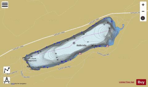

Suttle Lake Fishing Map Stats | |
| Title | Suttle Lake |
| Scale | 1:6000 |
| Counties | Jefferson |
| Nearby Cities | Camp Sherman, Sisters, Idanha, McKenzie Bridge, Tumalo, Detroit, Culver, Bend, Terrebonne, Warm Springs |
| Area * | 264.95 acres |
| Shoreline * | 3.57 miles |
| Min Longitude | -121.76 |
| Min Latitude | 44.42 |
| Max Longitude | -121.73 |
| Max Latitude | 44.43 |
| Edition Label 1 | |
| Edition Label 2 | |
| Edition Label 3 | |
| Id | US_OR_ordfw_suttle_lake |
| Country | US |
| Projection | Mercator |
| * some Stats may include nearby/connecting waterbodies | |
|