Loon Lake fishing map is available as part of iBoating : USA Marine & Fishing App(now supported on multiple platforms including Android, iPhone/iPad, MacBook, and Windows(tablet and phone)/PC based chartplotter.).
With our Lake Maps App, you get all the great marine chart app features like fishing spots, along with Loon Lake depth map. The fishing maps app include HD lake depth contours, along with advanced features found in Fish Finder / Gps Chart Plotter systems, turning your device into a Depth Finder. The Loon Lake Navigation App provides advanced features of a Marine Chartplotter including adjusting water level offset and custom depth shading. Fishing spots and depth contours layers are available in most Lake maps. Lake navigation features include advanced instrumentation to gather wind speed direction, water temperature, water depth, and accurate GPS with AIS receivers(using NMEA over TCP/UDP). Autopilot support can be enabled during ‘Goto WayPoint’ and ‘Route Assistance’.
Now i-Boating supports Fishing Points in Loon Lake.
Have more questions about the Nautical Chart App? Ask us.
Fishing Info for Loon Lake
Loon Lake is a 294-acre (119 ha) lake in Douglas County in the Oregon Coast Range of the United States, 15 miles (24 km) east-southeast of Reedsport, Oregon, at an elevation of 392 feet (119 m). The lake is about 2 miles (3 km) long with a maximum width of about 0.4 miles (0.6 km), and is over 100 feet (30 m) deep in some places. The lake is "a classic example of a landslide lake", dammed by a slide of sandstone blocks which fell into the Lake Creek valley about 1,400 years ago. The lake was discovered in 1852 and named for the loons found on its waters.
More on Wikipedia...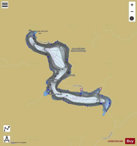

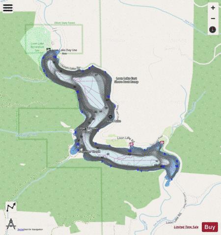
Loon Lake Fishing Map Stats | |
| Title | Loon Lake |
| Scale | 1:6000 |
| Counties | Douglas |
| Nearby Cities | Scottsburg, Allegany, Elkton, Reedsport, Gardiner, Lakeside, Winchester Bay, Siltcoos, Hauser, Dunes City |
| Area * | 258.39 acres |
| Shoreline * | 5.26 miles |
| Min Longitude | -123.85 |
| Min Latitude | 43.58 |
| Max Longitude | -123.82 |
| Max Latitude | 43.60 |
| Edition Label 1 | |
| Edition Label 2 | |
| Edition Label 3 | |
| Id | US_OR_ordfw_loon_lake |
| Country | US |
| Projection | Mercator |
| * some Stats may include nearby/connecting waterbodies | |
|