Rogers fishing map is available as part of iBoating : USA Marine & Fishing App(now supported on multiple platforms including Android, iPhone/iPad, MacBook, and Windows(tablet and phone)/PC based chartplotter.).
With our Lake Maps App, you get all the great marine chart app features like fishing spots, along with Rogers lake depth map. The fishing maps app include HD lake depth contours, along with advanced features found in Fish Finder / Gps Chart Plotter systems, turning your device into a Depth Finder. The Rogers Navigation App provides advanced features of a Marine Chartplotter including adjusting water level offset and custom depth shading. Fishing spots and depth contours layers are available in most Lake maps. Lake navigation features include advanced instrumentation to gather wind speed direction, water temperature, water depth, and accurate GPS with AIS receivers(using NMEA over TCP/UDP). Autopilot support can be enabled during ‘Goto WayPoint’ and ‘Route Assistance’.
Now i-Boating supports Fishing Points in Rogers.
Have more questions about the Nautical Chart App? Ask us.
Fishing Info for Rogers
Rogers Lake is a lake in Dakota County, in the U.S. state of Minnesota. Rogers Lake was named for E. G. Rogers, a pioneer farmer who settled there. Wagon Wheel Trail divides the two sections of the lake (the northern is sometimes referred to as "Mendakota Lake") which are connected by a culvert (a popular fishing spot). The south shore is occupied by Saint Thomas Academy and the Patterson Companies headquarters. Interstate 35E is routed along the western shore. A paved trail runs between 35E and the lake, from Mendota Heights Road to Rogers Lake Parm. The park is located on the northwest corner of the lower lake, and is a popular area for fishing and skateboarding in the summer. Mendakota Country Club surrounds the northern section. The remainder of the shoreline is occupied by private homes and accompanying land.
More on Wikipedia...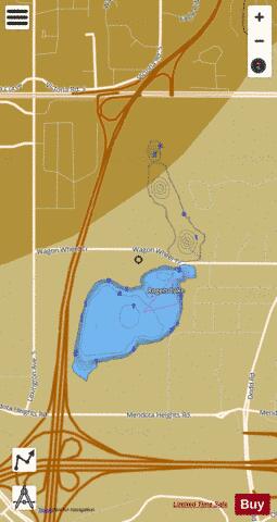
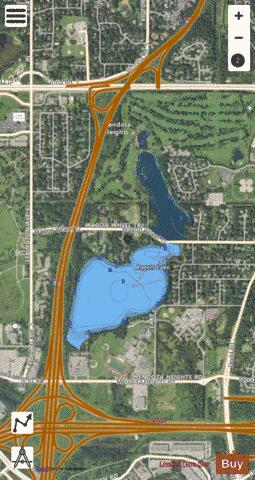
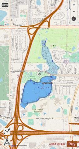
Rogers Fishing Map Stats | |
| Title | Rogers |
| Scale | 1:3000 |
| Counties | Dakota |
| Nearby Cities | Mendota Heights, Mendota, Sunfish Lake, Lilydale, West Saint Paul, Eagan, Saint Paul, Inver Grove Heights, South Saint Paul, Falcon Heights |
| Area * | 102.42 acres |
| Shoreline * | 2.99 miles |
| Min Longitude | -93.14 |
| Min Latitude | 44.87 |
| Max Longitude | -93.13 |
| Max Latitude | 44.88 |
| Edition Label 1 | |
| Edition Label 2 | |
| Edition Label 3 | |
| Id | US_MN_19008000 |
| Country | US |
| Projection | Mercator |
| * some Stats may include nearby/connecting waterbodies | |
|