Pleasant Lake fishing map is available as part of iBoating : USA Marine & Fishing App(now supported on multiple platforms including Android, iPhone/iPad, MacBook, and Windows(tablet and phone)/PC based chartplotter.).
With our Lake Maps App, you get all the great marine chart app features like fishing spots, along with Pleasant Lake depth map. The fishing maps app include HD lake depth contours, along with advanced features found in Fish Finder / Gps Chart Plotter systems, turning your device into a Depth Finder. The Pleasant Lake Navigation App provides advanced features of a Marine Chartplotter including adjusting water level offset and custom depth shading. Fishing spots and depth contours layers are available in most Lake maps. Lake navigation features include advanced instrumentation to gather wind speed direction, water temperature, water depth, and accurate GPS with AIS receivers(using NMEA over TCP/UDP). Autopilot support can be enabled during ‘Goto WayPoint’ and ‘Route Assistance’.
Now i-Boating supports Fishing Points in Pleasant Lake.
Have more questions about the Nautical Chart App? Ask us.
Fishing Info for Pleasant Lake
Pleasant Lake extends through southern Otisfield into northern Casco, Maine. The lake shoreline is heavily developed with residences and seasonal cabins. It is one of the finest spring fed lakes in the state of Maine. The southern end of the lake overflows as Mill Brook through the village of Casco, and reaches the Crooked River 3 miles (4.8 km) to the southwest. The lake supports a thriving population of white perch with some smallmouth bass and chain pickerel; and has been stocked with brown trout, lake trout, and land-locked Atlantic salmon. A boat launch area is available at the southern end of the lake. Seeds of Peace, an international conflict resolution summer camp, is based on Pleasant Lake.
More on Wikipedia...Popular fish species in this lake include Atlantic salmon, Chain pickerel, Lake trout and Smallmouth bass.
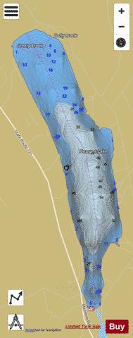
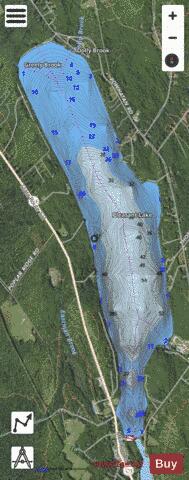
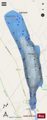
Pleasant Lake Fishing Map Stats | |
| Title | Pleasant Lake |
| Scale | 1:6000 |
| Counties | Cumberland, Oxford |
| Nearby Cities | Casco, Oxford, Naples, Raymond, Poland, Mechanic Falls, Harrison, Norway, Frye Island, South Paris |
| Area * | 1332.58 acres |
| Shoreline * | 9.02 miles |
| Min Longitude | -70.54 |
| Min Latitude | 44.01 |
| Max Longitude | -70.51 |
| Max Latitude | 44.06 |
| Edition Label 1 | |
| Edition Label 2 | |
| Edition Label 3 | |
| Id | US_ME_00573487 |
| Country | US |
| Projection | Mercator |
| * some Stats may include nearby/connecting waterbodies | |
|