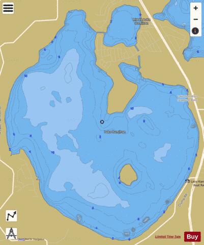
LAKE HAMILTON fishing map is available as part of iBoating : USA Marine & Fishing App(now supported on multiple platforms including Android, iPhone/iPad, MacBook, and Windows(tablet and phone)/PC based chartplotter.).
With our Lake Maps App, you get all the great marine chart app features like fishing spots, along with LAKE HAMILTON depth map. The fishing maps app include HD lake depth contours, along with advanced features found in Fish Finder / Gps Chart Plotter systems, turning your device into a Depth Finder. The LAKE HAMILTON Navigation App provides advanced features of a Marine Chartplotter including adjusting water level offset and custom depth shading. Fishing spots and depth contours layers are available in most Lake maps. Lake navigation features include advanced instrumentation to gather wind speed direction, water temperature, water depth, and accurate GPS with AIS receivers(using NMEA over TCP/UDP). Autopilot support can be enabled during ‘Goto WayPoint’ and ‘Route Assistance’.
Now i-Boating supports Fishing Points in LAKE HAMILTON.
Have more questions about the Nautical Chart App? Ask us.
Fishing Info for LAKE HAMILTON
Lake Hamilton is somewhat round with a large cove at its northwest edge. It also has a peninsula, sometimes called Bonars Island, on its north side that juts about 2,000 feet (610 m) south into the lake. During times of high water levels this peninsula becomes a large island. Lake Hamilton has a surface area of 2,184-acre (8,840,000 m2). One large island is in the south-central part of the lake; it measures 1,410 feet (430 m) long by 1,060 feet (320 m) wide. Another large island is near the northeast shore of Lake Hamilton; it measures 825 feet (251 m) long by 470 feet (140 m) wide. At least two small islands are also within Lake Hamilton. Lake Hamilton is one of the largest lakes in the Winter Haven area. Parts of its shoreline are surrounded by residential areas. The lake has a mobile home park on its northeast shore. A golf course borders the lake along all the southwest shore and US Highway 27 runs close to the lake along much of its east shore. A swamp borders the lake at the north end of the cove. The public has limited access to the shores of this lake. The only public access is at Sample Park, along US 27. This park has a picnic area and a public boat ramp. There are no public swimming areas at Lake Hamilton. Lake Hamilton is part of the north system of the Winter Haven Chain of Lakes. It is connected by a boat lift, which is not currently functioning, in a canal on its west side to Lake Fannie, on its north side to Lake Henry and on its east side to Middle Lake Hamilton. The TakeMeFishing.Org website does not specifically say anything about the fish in this lake. It says The chain of lakes of which it is a part contain largemouth bass, black crappie and bluegill.
More on Wikipedia...Popular fish species in this lake include Black crappie and Largemouth bass.
LAKE HAMILTON Fishing Map Stats | |
| Title | LAKE HAMILTON |
| Scale | 1:12000 |
| 1 ft Depth Contours for Anglers | Yes |
| Counties | Polk |
| Nearby Cities | Lake Hamilton, Dundee, Haines City, Lake Alfred, Waverly, Winter Haven, Inwood, Davenport, Wahneta, Eagle Lake |
| Area * | 2239.41 acres |
| Shoreline * | 12.37 miles |
| Min Longitude | -81.67 |
| Min Latitude | 28.03 |
| Max Longitude | -81.63 |
| Max Latitude | 28.07 |
| Edition Label 1 | |
| Edition Label 2 | |
| Edition Label 3 | |
| Id | US_FL_00283642 |
| Country | US |
| Projection | Mercator |
| * some Stats may include nearby/connecting waterbodies | |
|


