Lake Mattoon fishing map is available as part of iBoating : USA Marine & Fishing App(now supported on multiple platforms including Android, iPhone/iPad, MacBook, and Windows(tablet and phone)/PC based chartplotter.).
With our Lake Maps App, you get all the great marine chart app features like fishing spots, along with Lake Mattoon depth map. The fishing maps app include HD lake depth contours, along with advanced features found in Fish Finder / Gps Chart Plotter systems, turning your device into a Depth Finder. The Lake Mattoon Navigation App provides advanced features of a Marine Chartplotter including adjusting water level offset and custom depth shading. Fishing spots and depth contours layers are available in most Lake maps. Lake navigation features include advanced instrumentation to gather wind speed direction, water temperature, water depth, and accurate GPS with AIS receivers(using NMEA over TCP/UDP). Autopilot support can be enabled during ‘Goto WayPoint’ and ‘Route Assistance’.
Now i-Boating supports Fishing Points in Lake Mattoon.
Have more questions about the Nautical Chart App? Ask us.
Fishing Info for Lake Mattoon
Lake Mattoon is a 1,050-acre (4.2 km²) reservoir located in Coles County, Illinois, Cumberland County, Illinois, and Shelby County, Illinois. Almost three-quarters of the lake, 765 acres (3.1 km²), is located in Shelby County. The reservoir was built to supply tap water to Mattoon, Illinois and Neoga, but also provides fishing and boating recreation. The lake is 4 miles (6.4 km) long and 0.5 miles (0.8 km) wide. The lake is owned by the city of Mattoon. Boaters must buy a permit to use the lake. There is no power limit on the lake, which welcomes waterskiers. The lake is stocked with bass, bluegill, catfish, and crappie. The nearest Interstate access is Exit 177 on Interstate 57. A large Reliant Energy electricity generating plant stands adjacent to the lake.
More on Wikipedia...Popular fish species in this lake include Crappie.
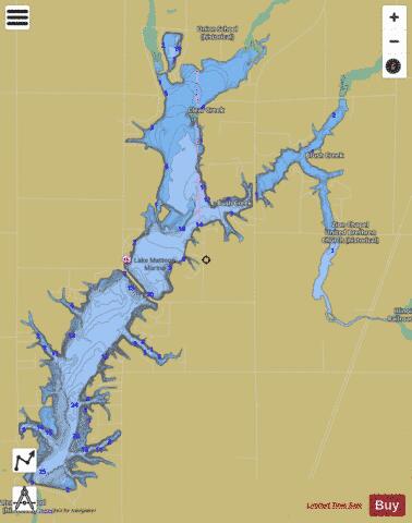


Lake Mattoon Fishing Map Stats | |
| Title | Lake Mattoon |
| Scale | 1:12000 |
| Counties | Coles, Cumberland, Shelby |
| Nearby Cities | Neoga, Trowbridge, Gays, Sigel, Mattoon, Strasburg, Windsor, Lerna, Stewardson, Allenville |
| Area * | 1024.81 acres |
| Shoreline * | 32.80 miles |
| Min Longitude | -88.49 |
| Min Latitude | 39.33 |
| Max Longitude | -88.43 |
| Max Latitude | 39.38 |
| Edition Label 1 | |
| Edition Label 2 | |
| Edition Label 3 | |
| Id | US_CC_IL_lake_mattoon_m_ju22 |
| Country | US |
| Projection | Mercator |
| * some Stats may include nearby/connecting waterbodies | |
|