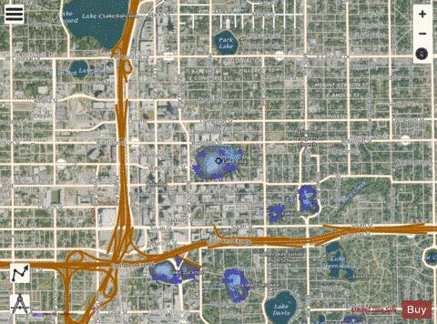
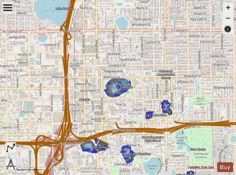
Lake Eola fishing map is available as part of iBoating : USA Marine & Fishing App(now supported on multiple platforms including Android, iPhone/iPad, MacBook, and Windows(tablet and phone)/PC based chartplotter.).
With our Lake Maps App, you get all the great marine chart app features like fishing spots, along with Lake Eola depth map. The fishing maps app include HD lake depth contours, along with advanced features found in Fish Finder / Gps Chart Plotter systems, turning your device into a Depth Finder. The Lake Eola Navigation App provides advanced features of a Marine Chartplotter including adjusting water level offset and custom depth shading. Fishing spots and depth contours layers are available in most Lake maps. Lake navigation features include advanced instrumentation to gather wind speed direction, water temperature, water depth, and accurate GPS with AIS receivers(using NMEA over TCP/UDP). Autopilot support can be enabled during ‘Goto WayPoint’ and ‘Route Assistance’.
Now i-Boating supports Fishing Points in Lake Eola.
Have more questions about the Nautical Chart App? Ask us.
Fishing Info for Lake Eola
Lake Eola Park is a public park located in Downtown Orlando, Florida. Lake Eola is the main feature of the park. Also located in the park (on the west side) is the Walt Disney Amphitheater, which hosts many community events and various performances year round. On the east side of the park is a Chinese pagoda, and a playground. The park is surrounded by four streets: East Robinson Street (State Road 526), Rosalind Avenue (SR 527), East Central Boulevard, and North Eola Drive.
More on Wikipedia...
Lake Eola Fishing Map Stats | |
| Title | Lake Eola |
| Scale | 1:3000 |
| 1 ft Depth Contours for Anglers | Yes |
| Counties | Orange |
| Nearby Cities | Orlando, Fairview Shores, Edgewood, Conway, Winter Park, Eatonville, Azalea Park, Pine Castle, Pine Hills, Maitland |
| Area * | 28.07 acres |
| Shoreline * | 0.84 miles |
| Min Longitude | -81.38 |
| Min Latitude | 28.54 |
| Max Longitude | -81.37 |
| Max Latitude | 28.55 |
| Edition Label 1 | |
| Edition Label 2 | |
| Edition Label 3 | |
| Id | US_CC_FL_orl_00282234_fl |
| Country | US |
| Projection | Mercator |
| * some Stats may include nearby/connecting waterbodies | |
|