Lake McQueeney fishing map is available as part of iBoating : USA Marine & Fishing App(now supported on multiple platforms including Android, iPhone/iPad, MacBook, and Windows(tablet and phone)/PC based chartplotter.).
With our Lake Maps App, you get all the great marine chart app features like fishing spots, along with Lake McQueeney depth map. The fishing maps app include HD lake depth contours, along with advanced features found in Fish Finder / Gps Chart Plotter systems, turning your device into a Depth Finder. The Lake McQueeney Navigation App provides advanced features of a Marine Chartplotter including adjusting water level offset and custom depth shading. Fishing spots and depth contours layers are available in most Lake maps. Lake navigation features include advanced instrumentation to gather wind speed direction, water temperature, water depth, and accurate GPS with AIS receivers(using NMEA over TCP/UDP). Autopilot support can be enabled during ‘Goto WayPoint’ and ‘Route Assistance’.
Now i-Boating supports Fishing Points in Lake McQueeney.
Have more questions about the Nautical Chart App? Ask us.
Fishing Info for Lake McQueeney
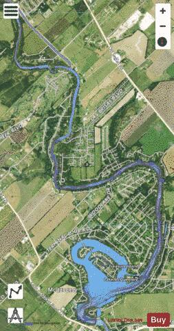
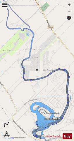
Lake McQueeney is a reservoir on the Guadalupe River located 5 miles (8 km) west of Seguin in Guadalupe County, Texas, United States. It was formed in 1928 by the construction of a dam to provide hydroelectric power to the area. Management of the dam and lake was assumed by the Guadalupe-Blanco River Authority on May 1, 1963. Its prominent feature is Treasure Island, a residential area that has been subjected to major flooding in 1972, 1998, and 2002. Most of it is approximately 10 feet (3 m) deep, with deeper sections along the center channel of the river. It is a venue for outdoor recreation, including fishing, boating, and swimming, and is maintained at a constant level year round. Amid concerns of aging dams along the lower Guadalupe River, the Guadalupe-Blanco River Authority announced that four lakes will be drained including lake McQueeny beginning Sept 16th (2019).
More on Wikipedia...Popular fish species in this lake include Largemouth bass, Spotted bass and White crappie.
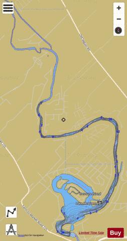
Lake McQueeney Fishing Map Stats | |
| Title | Lake McQueeney |
| Scale | 1:12000 |
| Counties | Guadalupe |
| Nearby Cities | McQueeney, Clear Springs, Lake Dunlap, Geronimo, Seguin, New Braunfels, Gruene, Marion, Santa Clara, Dittlinger |
| Area * | 363.29 acres |
| Shoreline * | 20.18 miles |
| Min Longitude | -98.06 |
| Min Latitude | 29.59 |
| Max Longitude | -98.03 |
| Max Latitude | 29.65 |
| Edition Label 1 | |
| Edition Label 2 | |
| Edition Label 3 | |
| Id | US_AA_TX_mcqueeney_tx |
| Country | US |
| Projection | Mercator |
| * some Stats may include nearby/connecting waterbodies | |
|