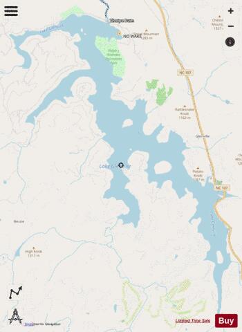
Lake Glenville fishing map is available as part of iBoating : USA Marine & Fishing App(now supported on multiple platforms including Android, iPhone/iPad, MacBook, and Windows(tablet and phone)/PC based chartplotter.).
With our Lake Maps App, you get all the great marine chart app features like fishing spots, along with Lake Glenville depth map. The fishing maps app include HD lake depth contours, along with advanced features found in Fish Finder / Gps Chart Plotter systems, turning your device into a Depth Finder. The Lake Glenville Navigation App provides advanced features of a Marine Chartplotter including adjusting water level offset and custom depth shading. Fishing spots and depth contours layers are available in most Lake maps. Lake navigation features include advanced instrumentation to gather wind speed direction, water temperature, water depth, and accurate GPS with AIS receivers(using NMEA over TCP/UDP). Autopilot support can be enabled during ‘Goto WayPoint’ and ‘Route Assistance’.
Have more questions about the Nautical Chart App? Ask us.
Fishing Info for Lake Glenville
Lake Glenville is a reservoir located 8 miles from Cashiers, North Carolina to the dam and public beach. The headwaters, at Hurricane Creek, are less than 2 miles. It was formed by the damming of the west fork of the Tuckasegee River in 1941. Between 1951 and 2002, it was officially known as "Thorpe Reservoir" after J. E. S. Thorpe, Nantahala Power's first president. It is still listed as such on many maps. The lake bottom plunges as steeply as the mountains that meet the shore. The depth a short distance from the water's edge may register 80 feet (24 m) or more. The lake has 26 miles (42 km) of shoreline and encompasses 1450 total acres. It is only a short twenty-minute drive from Western Carolina University, and the town of Sylva.
More on Wikipedia...

Lake Glenville Fishing Map Stats | |
| Title | Lake Glenville |
| Scale | 1:6000 |
| Counties | Jackson |
| Nearby Cities | Glenville, Cashiers, Highlands, Forest Hills, Cullowhee, Satolah, Webster, Sylva, Dillsboro, Scaly Mountain |
| Area * | 8456.28 acres |
| Shoreline * | 14.71 miles |
| Min Longitude | -83.18 |
| Min Latitude | 35.14 |
| Max Longitude | -83.12 |
| Max Latitude | 35.20 |
| Edition Label 1 | |
| Edition Label 2 | |
| Edition Label 3 | |
| Id | US_AA_NC_01027471 |
| Country | US |
| Projection | Mercator |
| * some Stats may include nearby/connecting waterbodies | |
|