Mountain Island Lake fishing map is available as part of iBoating : USA Marine & Fishing App(now supported on multiple platforms including Android, iPhone/iPad, MacBook, and Windows(tablet and phone)/PC based chartplotter.).
With our Lake Maps App, you get all the great marine chart app features like fishing spots, along with Mountain Island Lake depth map. The fishing maps app include HD lake depth contours, along with advanced features found in Fish Finder / Gps Chart Plotter systems, turning your device into a Depth Finder. The Mountain Island Lake Navigation App provides advanced features of a Marine Chartplotter including adjusting water level offset and custom depth shading. Fishing spots and depth contours layers are available in most Lake maps. Lake navigation features include advanced instrumentation to gather wind speed direction, water temperature, water depth, and accurate GPS with AIS receivers(using NMEA over TCP/UDP). Autopilot support can be enabled during ‘Goto WayPoint’ and ‘Route Assistance’.
Have more questions about the Nautical Chart App? Ask us.
Fishing Info for Mountain Island Lake
Mountain Island Lake is a lake northwest of Charlotte, North Carolina created in 1924 to coincide with the building of Mountain Island Hydroelectric Station. It is named after the mountain which appears as an island in the lake, and the surrounding area is identified by the lake's name. The shape of the lake follows the meander of the Catawba River's course, dammed near the Mount Holly Wastewater Plant. Full pond elevation is approximately 647.5 feet (197 m). The lake has around 3,281 acres (13 km2) of surface area and 61 miles (98 km) of shoreline.
More on Wikipedia...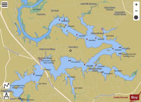


Mountain Island Lake Fishing Map Stats | |
| Title | Mountain Island Lake |
| Scale | 1:6000 |
| Counties | Gaston, Mecklenburg |
| Nearby Cities | Mount Holly, Paw Creek, Lowesville, Huntersville, Belmont, Stanley, McAdenville, Triangle, Spencer Mountain, Westport |
| Area * | 1961.58 acres |
| Shoreline * | 52.64 miles |
| Min Longitude | -81.00 |
| Min Latitude | 35.33 |
| Max Longitude | -80.91 |
| Max Latitude | 35.38 |
| Edition Label 1 | |
| Edition Label 2 | |
| Edition Label 3 | |
| Id | US_AA_NC_00990701 |
| Country | US |
| Projection | Mercator |
| * some Stats may include nearby/connecting waterbodies | |
|