Grändalssjön fishing map is included in Sweden - Stockholm Lakes nautical charts folio. It is available as part of iBoating : Inland Europe Marine & Fishing App (now supported on multiple platforms including Android, iPhone/iPad, MacBook, and Windows(tablet and phone)/PC based chartplotter. ).
With our Lake Maps App, you get all the great marine chart app features like fishing spots, along with Grändalssjön lake depth map. The fishing maps app include HD lake depth contours, along with advanced features found in Fish Finder / Gps Chart Plotter systems, turning your device into a Depth Finder. The Grändalssjön Navigation App provides advanced features of a Marine Chartplotter including adjusting water level offset and custom depth shading. Fishing spots and depth contours layers are available in most Lake maps. Lake navigation features include advanced instrumentation to gather wind speed direction, water temperature, water depth, and accurate GPS with AIS receivers(using NMEA over TCP/UDP). Autopilot support can be enabled during ‘Goto WayPoint’ and ‘Route Assistance’.
Have more questions about the Nautical Chart App? Ask us.
Fishing Info for Grändalssjön
Grändalssjön (Swedish for "Lake of Grändalen") is a small lake in Tyresö Municipality south-east of central Stockholm, Sweden. Grändalssjön, one of the lakes within the Tyresån Lake System, empties in its eastern end into a southbound bay of lake Albysjön located north of it. Immediately north of Grändalssjön is the Raksta open-air area, and Övre kärret ("Upper Swamp"), a swampy lake, is located west of the lake. Two small cottages located nearby, Grändalen and Skansen, are part of Gamla Tyresö. The lake is popular for bathing and fishing. Motorboats are not allowed on the lake. It is virtually unaffected by eutrophication and human activities. It consequently has moderate levels of nutrients. The stock of crayfishes is undocumented, but fishing using a maximum of ten tools is allowed with a fishing license. Aquatic vegetation is dominated by .
More on Wikipedia...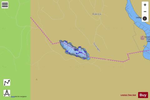
Grändalssjön Fishing Map Stats | |
| Title | Grändalssjön |
| Scale | 1:6000 |
| Area * | 17.83 acres |
| Shoreline * | 0.87 miles |
| Min Longitude | 18.29 |
| Min Latitude | 59.21 |
| Max Longitude | 18.30 |
| Max Latitude | 59.21 |
| Edition Label 1 | |
| Edition Label 2 | |
| Edition Label 3 | |
| Id | II_SE_656854_164187_se |
| Country | Inland Europe |
| Projection | Mercator |
| * some Stats may include nearby/connecting waterbodies | |
|