Loch Ruthven fishing map is included in Scotland - Highland Lochs nautical charts folio. It is available as part of iBoating : Inland Europe Marine & Fishing App (now supported on multiple platforms including Android, iPhone/iPad, MacBook, and Windows(tablet and phone)/PC based chartplotter. ).
With our Lake Maps App, you get all the great marine chart app features like fishing spots, along with Loch Ruthven lake depth map. The fishing maps app include HD lake depth contours, along with advanced features found in Fish Finder / Gps Chart Plotter systems, turning your device into a Depth Finder. The Loch Ruthven Navigation App provides advanced features of a Marine Chartplotter including adjusting water level offset and custom depth shading. Fishing spots and depth contours layers are available in most Lake maps. Lake navigation features include advanced instrumentation to gather wind speed direction, water temperature, water depth, and accurate GPS with AIS receivers(using NMEA over TCP/UDP). Autopilot support can be enabled during ‘Goto WayPoint’ and ‘Route Assistance’.
Have more questions about the Nautical Chart App? Ask us.
Fishing Info for Loch Ruthven
Loch Ruthven is a large loch which lies to the southeast of Loch Ness in the Highland region of Scotland. It is 2.25 miles (3.62 km) long, extends over an area of 368 acres (149 ha) and is up to 42 feet (13 m) deep. The most important breeding site in the UK for Slavonian grebes, it has one of the highest populations of this species in Europe. These rare birds can also be found in several other local lochs. The RSPB has established a reserve at Loch Ruthven. Loch Ruthven was designated a Ramsar site on 31 August 1992.
More on Wikipedia...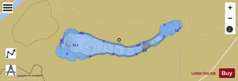
Loch Ruthven Fishing Map Stats | |
| Title | Loch Ruthven |
| Scale | 1:12000 |
| Area * | 375.70 acres |
| Shoreline * | 5.33 miles |
| Min Longitude | -4.32 |
| Min Latitude | 57.32 |
| Max Longitude | -4.27 |
| Max Latitude | 57.33 |
| Edition Label 1 | |
| Edition Label 2 | |
| Edition Label 3 | |
| Id | II_SCOT_74422262_1_scot |
| Country | Inland Europe |
| Projection | Mercator |
| * some Stats may include nearby/connecting waterbodies | |
| |||||||||||||||||||||||||||||||||||||||||||||||||||||||||||||||||||||||||||||||||||||||||||||||||||||||
|