Loch Ossian fishing map is included in Scotland - Highland Lochs nautical charts folio. It is available as part of iBoating : Inland Europe Marine & Fishing App (now supported on multiple platforms including Android, iPhone/iPad, MacBook, and Windows(tablet and phone)/PC based chartplotter. ).
With our Lake Maps App, you get all the great marine chart app features like fishing spots, along with Loch Ossian lake depth map. The fishing maps app include HD lake depth contours, along with advanced features found in Fish Finder / Gps Chart Plotter systems, turning your device into a Depth Finder. The Loch Ossian Navigation App provides advanced features of a Marine Chartplotter including adjusting water level offset and custom depth shading. Fishing spots and depth contours layers are available in most Lake maps. Lake navigation features include advanced instrumentation to gather wind speed direction, water temperature, water depth, and accurate GPS with AIS receivers(using NMEA over TCP/UDP). Autopilot support can be enabled during ‘Goto WayPoint’ and ‘Route Assistance’.
Have more questions about the Nautical Chart App? Ask us.
Fishing Info for Loch Ossian
Loch Ossian (Scottish Gaelic: "Loch Oisein") is a narrow loch that is about 5 kilometres (3.1 mi) long on the north eastern edge of Rannoch Moor, on The Corrour Estate, with its western corner 2 kilometres (1.2 mi) east of Corrour railway station. It is drained by the River Ossian, flowing north into Loch Guilbinn and ultimately to the River Spean at Moy. Loch Ossian is remote from public roads, and the nearest access is from Corrour railway station. On its banks near the western end of the loch stands Loch Ossian youth hostel, which belongs to the Scottish Youth Hostels Association (SYHA). The hostel was recently restored as an 'eco-hostel', boasting wind and solar power, and grey water and dry toilet systems. At the eastern end of the loch is Corrour Lodge.
More on Wikipedia...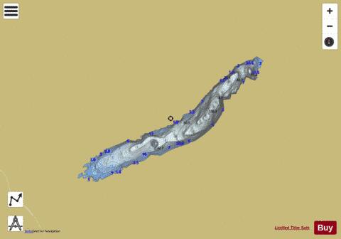
Loch Ossian Fishing Map Stats | |
| Title | Loch Ossian |
| Scale | 1:12000 |
| Area * | 619.55 acres |
| Shoreline * | 7.95 miles |
| Min Longitude | -4.67 |
| Min Latitude | 56.77 |
| Max Longitude | -4.60 |
| Max Latitude | 56.79 |
| Edition Label 1 | |
| Edition Label 2 | |
| Edition Label 3 | |
| Id | II_SCOT_74422245_0_scot |
| Country | Inland Europe |
| Projection | Mercator |
| * some Stats may include nearby/connecting waterbodies | |
| |||||||||||||||||||||||||||||||||||||||||||||||||||||||||||||||||||||||||||||||||||||||||||||||||||||||
|