Loch Achilty fishing map is included in Scotland - Highland Lochs nautical charts folio. It is available as part of iBoating : Inland Europe Marine & Fishing App (now supported on multiple platforms including Android, iPhone/iPad, MacBook, and Windows(tablet and phone)/PC based chartplotter. ).
With our Lake Maps App, you get all the great marine chart app features like fishing spots, along with Loch Achilty lake depth map. The fishing maps app include HD lake depth contours, along with advanced features found in Fish Finder / Gps Chart Plotter systems, turning your device into a Depth Finder. The Loch Achilty Navigation App provides advanced features of a Marine Chartplotter including adjusting water level offset and custom depth shading. Fishing spots and depth contours layers are available in most Lake maps. Lake navigation features include advanced instrumentation to gather wind speed direction, water temperature, water depth, and accurate GPS with AIS receivers(using NMEA over TCP/UDP). Autopilot support can be enabled during ‘Goto WayPoint’ and ‘Route Assistance’.
Have more questions about the Nautical Chart App? Ask us.
Fishing Info for Loch Achilty
Loch Achilty is a large picturesque lowland freshwater loch set within a sloping birch and oakwood forest, and located near to Contin in Ross-shire, Scottish Highlands, Scotland. Loch Achilty is notable for having no outflow. It has been assumed that it is discharging its surplus water via tunnel into the River Rosay (now known as the Black Water) that eventually flows into the larger River Conon.
More on Wikipedia...Popular fish species in this lake include Salvelinus.
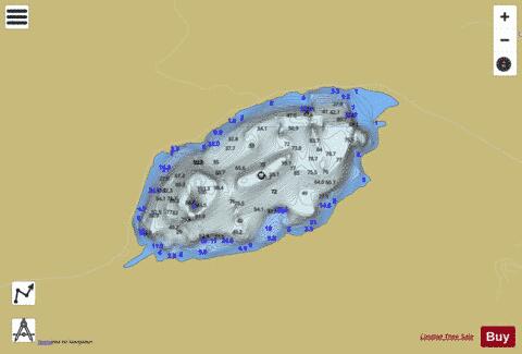
Loch Achilty Fishing Map Stats | |
| Title | Loch Achilty |
| Scale | 1:6000 |
| Area * | 149.37 acres |
| Shoreline * | 2.35 miles |
| Min Longitude | -4.63 |
| Min Latitude | 57.57 |
| Max Longitude | -4.61 |
| Max Latitude | 57.58 |
| Edition Label 1 | |
| Edition Label 2 | |
| Edition Label 3 | |
| Id | II_SCOT_74422220_3_scot |
| Country | Inland Europe |
| Projection | Mercator |
| * some Stats may include nearby/connecting waterbodies | |
| |||||||||||||||||||||||||||||||||||||||||||||||||||||||||||||||||||||||||||||||||||||||||||||||||||||||
|