Loch Eilt (Ailort Basin) fishing map is included in Scotland - Highland Lochs nautical charts folio. It is available as part of iBoating : Inland Europe Marine & Fishing App (now supported on multiple platforms including Android, iPhone/iPad, MacBook, and Windows(tablet and phone)/PC based chartplotter. ).
With our Lake Maps App, you get all the great marine chart app features like fishing spots, along with Loch Eilt (Ailort Basin) lake depth map. The fishing maps app include HD lake depth contours, along with advanced features found in Fish Finder / Gps Chart Plotter systems, turning your device into a Depth Finder. The Loch Eilt (Ailort Basin) Navigation App provides advanced features of a Marine Chartplotter including adjusting water level offset and custom depth shading. Fishing spots and depth contours layers are available in most Lake maps. Lake navigation features include advanced instrumentation to gather wind speed direction, water temperature, water depth, and accurate GPS with AIS receivers(using NMEA over TCP/UDP). Autopilot support can be enabled during ‘Goto WayPoint’ and ‘Route Assistance’.
Have more questions about the Nautical Chart App? Ask us.
Fishing Info for Loch Eilt (Ailort Basin)
Loch Eilt is a freshwater loch in Lochaber, in the West Highlands of Scotland. It is between the villages of Glenfinnan and Lochailort, 30 km west of Fort William. The A830 road runs along the north shore, while the West Highland Line railway follows the south shore. Loch Eilt separates the traditional districts of Morar to the north and Moidart to the south. The loch has a number of small islands, including Eilean Mòr, Eilean an Tighe, Eilean Gaineamhach, Eilean nan Corra-ghriodhach and Eilean na Mòine. Loch Eilt has been used as a location in several films. These include Local Hero (1980), Harry Potter and the Prisoner of Azkaban (2004) and Harry Potter and the Deathly Hallows – Part 1 (2010). The famous island used for Harry Potter in Loch Eilt is called Eilean na Moine. It was used as Dumbledore's grave, which was later digitally placed on Loch Arkaig.
More on Wikipedia...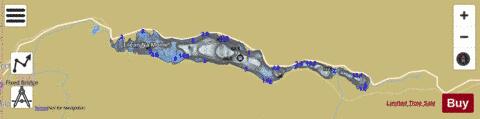
Loch Eilt (Ailort Basin) Fishing Map Stats | |
| Title | Loch Eilt (Ailort Basin) |
| Scale | 1:12000 |
| Area * | 451.02 acres |
| Shoreline * | 8.74 miles |
| Min Longitude | -5.63 |
| Min Latitude | 56.87 |
| Max Longitude | -5.54 |
| Max Latitude | 56.89 |
| Edition Label 1 | |
| Edition Label 2 | |
| Edition Label 3 | |
| Id | II_SCOT_74422214_0_scot |
| Country | Inland Europe |
| Projection | Mercator |
| * some Stats may include nearby/connecting waterbodies | |
| ||||||||||||||||||||||||||||||||||||||||||||||||||||||||||||||||||||||||||||||||||||||||||||||||||||||||
|