Loch Lubnaig fishing map is included in Scotland - Stirling Lochs nautical charts folio. It is available as part of iBoating : Inland Europe Marine & Fishing App (now supported on multiple platforms including Android, iPhone/iPad, MacBook, and Windows(tablet and phone)/PC based chartplotter. ).
With our Lake Maps App, you get all the great marine chart app features like fishing spots, along with Loch Lubnaig lake depth map. The fishing maps app include HD lake depth contours, along with advanced features found in Fish Finder / Gps Chart Plotter systems, turning your device into a Depth Finder. The Loch Lubnaig Navigation App provides advanced features of a Marine Chartplotter including adjusting water level offset and custom depth shading. Fishing spots and depth contours layers are available in most Lake maps. Lake navigation features include advanced instrumentation to gather wind speed direction, water temperature, water depth, and accurate GPS with AIS receivers(using NMEA over TCP/UDP). Autopilot support can be enabled during ‘Goto WayPoint’ and ‘Route Assistance’.
Have more questions about the Nautical Chart App? Ask us.
Fishing Info for Loch Lubnaig
Loch Lubnaig (Loch Lùbnaig in Gaelic) is a small freshwater loch near Callander in the Stirling council area, Scottish Highlands. It lies in the former county of Perthshire. It is part of the Loch Lomond and The Trossachs National Park. The loch nestles in the space between Ben Ledi and Ben Vorlich. Fed by the River Balvaig from the north and drained by the Garbh Uisge to the south, Loch Lubnaig offers fishing from the shore while canoes can be rented at the north end. Alternatively, two car parking areas on the east shore offer perfect, albeit sometimes busy, canoe launching points. The route of the former Callander and Oban Railway runs along the west shore of the loch. This route has now been converted to a part of the National Cycle Network's "Route 7" allowing cyclists and walkers to travel the 9 miles (14 km) between Callander and Strathyre. The name is derived from the Gaelic Lùbnaig, meaning crooked. Like many lochs of the Highlands, the name is almost identical to its Gaelic version.
More on Wikipedia...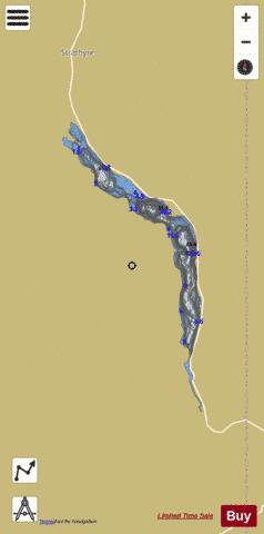
Loch Lubnaig Fishing Map Stats | |
| Title | Loch Lubnaig |
| Scale | 1:12000 |
| Area * | 597.93 acres |
| Shoreline * | 11.09 miles |
| Min Longitude | -4.33 |
| Min Latitude | 56.25 |
| Max Longitude | -4.28 |
| Max Latitude | 56.31 |
| Edition Label 1 | |
| Edition Label 2 | |
| Edition Label 3 | |
| Id | II_SCOT_74422086_0_scot |
| Country | Inland Europe |
| Projection | Mercator |
| * some Stats may include nearby/connecting waterbodies | |
| |||||||||||||||||||||||||||||||||||||||||||||||||||||||||||||||||||||||||||||||||||||||||||||||||||||||
|