Loch Of Skene fishing map is included in Scotland - Aberdeenshire Lochs nautical charts folio. It is available as part of iBoating : Inland Europe Marine & Fishing App (now supported on multiple platforms including Android, iPhone/iPad, MacBook, and Windows(tablet and phone)/PC based chartplotter. ).
With our Lake Maps App, you get all the great marine chart app features like fishing spots, along with Loch Of Skene lake depth map. The fishing maps app include HD lake depth contours, along with advanced features found in Fish Finder / Gps Chart Plotter systems, turning your device into a Depth Finder. The Loch Of Skene Navigation App provides advanced features of a Marine Chartplotter including adjusting water level offset and custom depth shading. Fishing spots and depth contours layers are available in most Lake maps. Lake navigation features include advanced instrumentation to gather wind speed direction, water temperature, water depth, and accurate GPS with AIS receivers(using NMEA over TCP/UDP). Autopilot support can be enabled during ‘Goto WayPoint’ and ‘Route Assistance’.
Have more questions about the Nautical Chart App? Ask us.
Fishing Info for Loch Of Skene
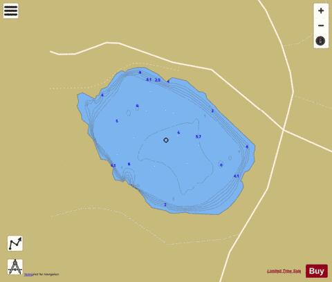
Loch of Skene is a large lowland, freshwater loch in Aberdeenshire, Scotland. It lies approximately 1 mi (1.6 km) to the west of the village of Kirkton of Skene and 9 mi (14 km) west of Aberdeen. The loch is partially man-made, being dammed at its outflow on the southern shore to form a reservoir. Before 1905, water from the loch was used in the making of tweed and to turn the mill wheel at the Garlogie Mills. When the mills closed in 1905 the water was used to generate electricity. The loch is about 6 foot deep at its deepest.
More on Wikipedia...Popular fish species in this lake include Northern pike.
Loch Of Skene Fishing Map Stats | |
| Title | Loch Of Skene |
| Scale | 1:12000 |
| Area * | 277.59 acres |
| Shoreline * | 2.70 miles |
| Min Longitude | -2.37 |
| Min Latitude | 57.15 |
| Max Longitude | -2.35 |
| Max Latitude | 57.16 |
| Edition Label 1 | |
| Edition Label 2 | |
| Edition Label 3 | |
| Id | II_SCOT_74400516_1_scot |
| Country | Inland Europe |
| Projection | Mercator |
| * some Stats may include nearby/connecting waterbodies | |
| ||||||||||||||||||||||||||||||||||||||||||||||||||||||||||||||||||||||||||||||||||||||||||||||||||||||||
|