Lochaber Loch (Nith Basin) fishing map is included in Scotland - Dumfries and Galloway Lochs nautical charts folio. It is available as part of iBoating : Inland Europe Marine & Fishing App (now supported on multiple platforms including Android, iPhone/iPad, MacBook, and Windows(tablet and phone)/PC based chartplotter. ).
With our Lake Maps App, you get all the great marine chart app features like fishing spots, along with Lochaber Loch (Nith Basin) lake depth map. The fishing maps app include HD lake depth contours, along with advanced features found in Fish Finder / Gps Chart Plotter systems, turning your device into a Depth Finder. The Lochaber Loch (Nith Basin) Navigation App provides advanced features of a Marine Chartplotter including adjusting water level offset and custom depth shading. Fishing spots and depth contours layers are available in most Lake maps. Lake navigation features include advanced instrumentation to gather wind speed direction, water temperature, water depth, and accurate GPS with AIS receivers(using NMEA over TCP/UDP). Autopilot support can be enabled during ‘Goto WayPoint’ and ‘Route Assistance’.
Have more questions about the Nautical Chart App? Ask us.
Fishing Info for Lochaber Loch (Nith Basin)
Lochaber Loch is a small, lowland freshwater loch that lies among steep-sided hills, approximately 4.5 mi (7.2 km) to the west of Dumfries, Scotland. The loch is somewhat triangular in shape and is 0.5 mi (0.80 km) long and 0.25 mi (0.40 km) at its widest point. It has an average depth of 20.5 ft (6.2 m) and is 55 ft (17 m) at its deepest. The loch was surveyed on 4 May 1905 by James Murray and L.W. Collett as part of Sir John Murray's Bathymetrical Survey of Fresh-Water Lochs of Scotland 1897-1909. Swans, great crested grebes and ospreys can be seen on the loch. There is a bird hide on the water's edge. The loch in the Mabie Forest, which is managed by the Forestry Commission.
More on Wikipedia...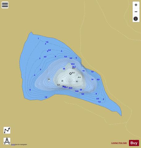
Lochaber Loch (Nith Basin) Fishing Map Stats | |
| Title | Lochaber Loch (Nith Basin) |
| Scale | 1:6000 |
| Area * | 41.69 acres |
| Shoreline * | 1.21 miles |
| Min Longitude | -3.69 |
| Min Latitude | 55.01 |
| Max Longitude | -3.68 |
| Max Latitude | 55.02 |
| Edition Label 1 | |
| Edition Label 2 | |
| Edition Label 3 | |
| Id | II_SCOT_74400513_1_scot |
| Country | Inland Europe |
| Projection | Mercator |
| * some Stats may include nearby/connecting waterbodies | |
| |||||||||||||||||||||||||||||||||||||||||||||||||||||||||||||||||||||||||||||||||||||||||||||||||||||||
|