Carrowmore Lake fishing map is included in Ireland - Loughs in Mayo nautical charts folio. It is available as part of iBoating : Inland Europe Marine & Fishing App (now supported on multiple platforms including Android, iPhone/iPad, MacBook, and Windows(tablet and phone)/PC based chartplotter. ).
With our Lake Maps App, you get all the great marine chart app features like fishing spots, along with Carrowmore Lake depth map. The fishing maps app include HD lake depth contours, along with advanced features found in Fish Finder / Gps Chart Plotter systems, turning your device into a Depth Finder. The Carrowmore Lake Navigation App provides advanced features of a Marine Chartplotter including adjusting water level offset and custom depth shading. Fishing spots and depth contours layers are available in most Lake maps. Lake navigation features include advanced instrumentation to gather wind speed direction, water temperature, water depth, and accurate GPS with AIS receivers(using NMEA over TCP/UDP). Autopilot support can be enabled during ‘Goto WayPoint’ and ‘Route Assistance’.
Have more questions about the Nautical Chart App? Ask us.
Fishing Info for Carrowmore Lake
Carrowmore Lake (Irish: Loch na Ceathrún Móire) is situated in the parishes of Belmullet, Kiltane and Kilcommon Erris, County Mayo between the villages of Bangor Erris and at the southern end of Broadhaven Bay. The freshwater lake is over 4 miles (6 km) long and almost 3 miles (5 km) wide at its widest point. Glencullen's two townlands line its eastern shore and Rathmorgan and the Knocknascollop mountains rise up along its western shores. Carrowmore is not a deep lake and it provides the drinking water for the whole of the Erris area. It is fed by the Carrowmore River and drains into the Owenmore River on its way to Blacksod Bay. The lake is designated as a S.P.A. (Birds directive) in E.U. law and also as 000476 Complex S.A.C. (Special Area of Conservation). It is an oligotrophic/mesotrophic lake with a substrate of Dalradian schists and pale quartzite. Its shorelines are dominated by blanket bog mainly but there are many houses, mainly linear in layout, along both sides of its shores. Its catchment area includes the townland of Bellanaboy in Kilcommon where the contentious Corrib Gas refinery is situated.
More on Wikipedia...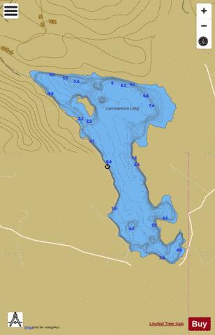
Carrowmore Lake Fishing Map Stats | |
| Title | Carrowmore Lake |
| Scale | 1:24000 |
| Area * | 2260.82 acres |
| Shoreline * | 15.42 miles |
| Min Longitude | -9.82 |
| Min Latitude | 54.16 |
| Max Longitude | -9.76 |
| Max Latitude | 54.21 |
| Edition Label 1 | |
| Edition Label 2 | |
| Edition Label 3 | |
| Id | II_IE_33_1914_Carrowmore |
| Country | Inland Europe |
| Projection | Mercator |
| * some Stats may include nearby/connecting waterbodies | |
| |||||||||||||||||||||||||||||||||||||||||||||||||||||||||||||||||||||||||||||||||||||||||||||||||||||||
|