Funshinagh ( Lough ) fishing map is included in Ireland - Loughs in Roscommon nautical charts folio. It is available as part of iBoating : Inland Europe Marine & Fishing App (now supported on multiple platforms including Android, iPhone/iPad, MacBook, and Windows(tablet and phone)/PC based chartplotter. ).
With our Lake Maps App, you get all the great marine chart app features like fishing spots, along with Funshinagh ( Lough ) lake depth map. The fishing maps app include HD lake depth contours, along with advanced features found in Fish Finder / Gps Chart Plotter systems, turning your device into a Depth Finder. The Funshinagh ( Lough ) Navigation App provides advanced features of a Marine Chartplotter including adjusting water level offset and custom depth shading. Fishing spots and depth contours layers are available in most Lake maps. Lake navigation features include advanced instrumentation to gather wind speed direction, water temperature, water depth, and accurate GPS with AIS receivers(using NMEA over TCP/UDP). Autopilot support can be enabled during ‘Goto WayPoint’ and ‘Route Assistance’.
Have more questions about the Nautical Chart App? Ask us.
Fishing Info for Funshinagh ( Lough )
Lough Funshinagh (Irish: Loch Fuinseann, meaning 'lake of the ash tree') is a lake and Special Area of Conservation in County Roscommon, Ireland, found to the west of Lough Ree. It has been called Ireland's amazing disappearing lake, due to the way it empties quickly - in as little as two days - and unpredictably, sometimes killing thousands of fish. Lough Funshinagh is one of a number of seasonal lakes, or turlough, found in the karst areas of Ireland, west of the River Shannon.
More on Wikipedia...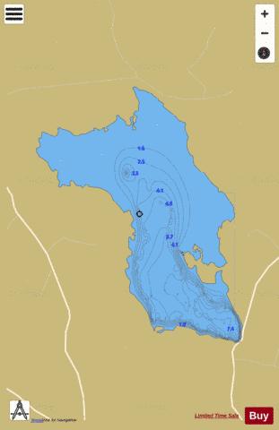
Funshinagh ( Lough ) Fishing Map Stats | |
| Title | Funshinagh ( Lough ) |
| Scale | 1:12000 |
| Area * | 941.42 acres |
| Shoreline * | 9.67 miles |
| Min Longitude | -8.12 |
| Min Latitude | 53.50 |
| Max Longitude | -8.08 |
| Max Latitude | 53.53 |
| Edition Label 1 | |
| Edition Label 2 | |
| Edition Label 3 | |
| Id | II_IE_26_701_Funshinagh |
| Country | Inland Europe |
| Projection | Mercator |
| * some Stats may include nearby/connecting waterbodies | |
|