Currane (Lough) fishing map is included in Ireland - Loughs in Kerry nautical charts folio. It is available as part of iBoating : Inland Europe Marine & Fishing App (now supported on multiple platforms including Android, iPhone/iPad, MacBook, and Windows(tablet and phone)/PC based chartplotter. ).
With our Lake Maps App, you get all the great marine chart app features like fishing spots, along with Currane (Lough) lake depth map. The fishing maps app include HD lake depth contours, along with advanced features found in Fish Finder / Gps Chart Plotter systems, turning your device into a Depth Finder. The Currane (Lough) Navigation App provides advanced features of a Marine Chartplotter including adjusting water level offset and custom depth shading. Fishing spots and depth contours layers are available in most Lake maps. Lake navigation features include advanced instrumentation to gather wind speed direction, water temperature, water depth, and accurate GPS with AIS receivers(using NMEA over TCP/UDP). Autopilot support can be enabled during ‘Goto WayPoint’ and ‘Route Assistance’.
Have more questions about the Nautical Chart App? Ask us.
Fishing Info for Currane (Lough)
Lough Currane (Irish: Loch Luíoch), also called Lough Leeagh, is a lake in County Kerry, Ireland. Waterville lies on its western bank, close to the Atlantic Ocean, it empties into Ballinskelligs Bay. lies on its southern bank. It covers an area of 2,500 acres (10 km2) and is 3.5 miles (5.6 km) long and 2 miles (3.2 km) at the widest point.The lake is notable for the Early Medieval monastery on Church Island. It is associated with had the St. Finan Cam, who inhabited the island c. 7th century. To the south of the lake is Inis Uasal (Noble Island), an island dedicated to St. Finan. The Annals of Inisfallen mention that Amchad, the "anchorite of God" was buried on the island in 1058.
More on Wikipedia...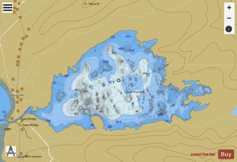
Currane (Lough) Fishing Map Stats | |
| Title | Currane (Lough) |
| Scale | 1:24000 |
| Area * | 2549.54 acres |
| Shoreline * | 20.13 miles |
| Min Longitude | -10.17 |
| Min Latitude | 51.82 |
| Max Longitude | -10.08 |
| Max Latitude | 51.85 |
| Edition Label 1 | |
| Edition Label 2 | |
| Edition Label 3 | |
| Id | II_IE_21_457_Currane |
| Country | Inland Europe |
| Projection | Mercator |
| * some Stats may include nearby/connecting waterbodies | |
| |||||||||||||||||||||||||||||||||||||||||||||||||||||||||||||||||||||||||||||||||||||||||||||||||||||||
|