Tay ( Lough ) fishing map is included in Ireland - Loughs in Wicklow nautical charts folio. It is available as part of iBoating : Inland Europe Marine & Fishing App (now supported on multiple platforms including Android, iPhone/iPad, MacBook, and Windows(tablet and phone)/PC based chartplotter. ).
With our Lake Maps App, you get all the great marine chart app features like fishing spots, along with Tay ( Lough ) lake depth map. The fishing maps app include HD lake depth contours, along with advanced features found in Fish Finder / Gps Chart Plotter systems, turning your device into a Depth Finder. The Tay ( Lough ) Navigation App provides advanced features of a Marine Chartplotter including adjusting water level offset and custom depth shading. Fishing spots and depth contours layers are available in most Lake maps. Lake navigation features include advanced instrumentation to gather wind speed direction, water temperature, water depth, and accurate GPS with AIS receivers(using NMEA over TCP/UDP). Autopilot support can be enabled during ‘Goto WayPoint’ and ‘Route Assistance’.
Have more questions about the Nautical Chart App? Ask us.
Fishing Info for Tay ( Lough )
Lough Tay (Irish: Loch Té), is a small but scenic lake set on private property in the Wicklow Mountains in Ireland. The lake lies between the mountains of Djouce 725 metres (2,379 ft), and Luggala 595 metres (1,952 ft), and is dominated by Luggala's east-facing granite cliffs. The lough is fed by the Cloghoge River, which then drains into Lough Dan to the south. Lough Tay forms part of the Guinness Estate at Luggala, and has limited public access.
More on Wikipedia...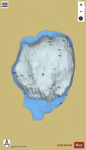
Tay ( Lough ) Fishing Map Stats | |
| Title | Tay ( Lough ) |
| Scale | 1:6000 |
| Area * | 123.50 acres |
| Shoreline * | 1.75 miles |
| Min Longitude | -6.27 |
| Min Latitude | 53.10 |
| Max Longitude | -6.26 |
| Max Latitude | 53.11 |
| Edition Label 1 | |
| Edition Label 2 | |
| Edition Label 3 | |
| Id | II_IE_10_25_Tay |
| Country | Inland Europe |
| Projection | Mercator |
| * some Stats may include nearby/connecting waterbodies | |
| |||||||||||||||||||||||||||||||||||||||||||||||||||||||||||||||||||||||||||||||||||||||||||||||||||||||
|