Schliersee fishing map is included in Germany - Bavaria Lakes nautical charts folio. It is available as part of iBoating : Inland Europe Marine & Fishing App (now supported on multiple platforms including Android, iPhone/iPad, MacBook, and Windows(tablet and phone)/PC based chartplotter. ).
With our Lake Maps App, you get all the great marine chart app features like fishing spots, along with Schliersee lake depth map. The fishing maps app include HD lake depth contours, along with advanced features found in Fish Finder / Gps Chart Plotter systems, turning your device into a Depth Finder. The Schliersee Navigation App provides advanced features of a Marine Chartplotter including adjusting water level offset and custom depth shading. Fishing spots and depth contours layers are available in most Lake maps. Lake navigation features include advanced instrumentation to gather wind speed direction, water temperature, water depth, and accurate GPS with AIS receivers(using NMEA over TCP/UDP). Autopilot support can be enabled during ‘Goto WayPoint’ and ‘Route Assistance’.
Have more questions about the Nautical Chart App? Ask us.
Fishing Info for Schliersee
Schliersee is a natural lake in Upper Bavaria in the Bavarian Alps. It is located next to the small town of Schliersee in the Miesbach district. The lake has a surface of 2.241 square kilometres (0.865 sq mi) at an elevation of 777 metres (2,549 ft) AMSL, expanding 2.3 kilometres (1.4 mi) by 1.3 kilometres (0.81 mi) maximum. The average depth is 20 metres (66 ft) The maximum depth is 40 metres (130 ft). The only island is Wörth island, located almost in the middle of the lake. The lake is named for the monastery Kloster Schliersee ("Sliersee"), established in 779 at Kirchbichl nearby Westenhofen.
More on Wikipedia...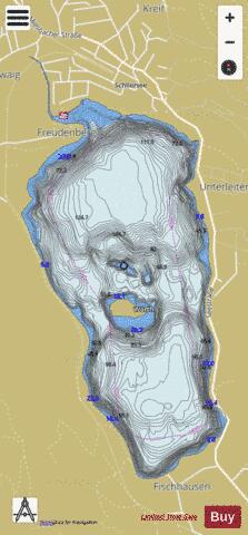
Schliersee Fishing Map Stats | |
| Title | Schliersee |
| Scale | 1:12000 |
| Area * | 531.01 acres |
| Shoreline * | 5.41 miles |
| Min Longitude | 11.85 |
| Min Latitude | 47.71 |
| Max Longitude | 11.87 |
| Max Latitude | 47.74 |
| Edition Label 1 | |
| Edition Label 2 | |
| Edition Label 3 | |
| Id | II_DE_BY_schliersee |
| Country | Inland Europe |
| Projection | Mercator |
| * some Stats may include nearby/connecting waterbodies | |
|