Ammersee fishing map is included in Germany - Bavaria Lakes nautical charts folio. It is available as part of iBoating : Inland Europe Marine & Fishing App (now supported on multiple platforms including Android, iPhone/iPad, MacBook, and Windows(tablet and phone)/PC based chartplotter. ).
With our Lake Maps App, you get all the great marine chart app features like fishing spots, along with Ammersee lake depth map. The fishing maps app include HD lake depth contours, along with advanced features found in Fish Finder / Gps Chart Plotter systems, turning your device into a Depth Finder. The Ammersee Navigation App provides advanced features of a Marine Chartplotter including adjusting water level offset and custom depth shading. Fishing spots and depth contours layers are available in most Lake maps. Lake navigation features include advanced instrumentation to gather wind speed direction, water temperature, water depth, and accurate GPS with AIS receivers(using NMEA over TCP/UDP). Autopilot support can be enabled during ‘Goto WayPoint’ and ‘Route Assistance’.
Have more questions about the Nautical Chart App? Ask us.
Fishing Info for Ammersee
Ammersee (English: Lake Ammer) is a Zungenbecken lake in Upper Bavaria, Germany, southwest of Munich between the towns of Herrsching and Dießen am Ammersee. With a surface area of approximately 47 square kilometres (18 sq mi), it is the sixth largest lake in Germany. The lake is at an elevation of 533 metres (1,749 ft), and has a maximum depth of 81 metres (266 ft). Like other Bavarian lakes, Ammersee developed as a result of the ice age glaciers melting. Ammersee is fed by the River Ammer, which flows as the Amper out of the lake. Like neighbouring Lake Starnberg - deeper, bigger in surface area, similar in shape - it is a popular location for watersports. Ammersee and the Amper are part of the ancient Celtic amber trading route leading to the Brenner Pass. The word Ammer is a 13th-century form of Amper, the Celtic *ambra, deriving from the Indo-European *ombh-, *mbh- "wet, Water". Passenger services have operated on the lake since 1879. Today they are operated by the Bayerische Seenschifffahrt company, using a mixture of historic paddle steamers and motor ships.
More on Wikipedia...Popular fish species in this lake include Salvelinus evasus.
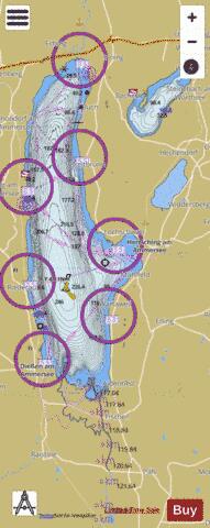
Ammersee Fishing Map Stats | |
| Title | Ammersee |
| Scale | 1:24000 |
| Area * | 12618.63 acres |
| Shoreline * | 61.42 miles |
| Min Longitude | 11.09 |
| Min Latitude | 47.91 |
| Max Longitude | 11.20 |
| Max Latitude | 48.08 |
| Edition Label 1 | |
| Edition Label 2 | |
| Edition Label 3 | |
| Id | II_DE_BY_ammersee |
| Country | Inland Europe |
| Projection | Mercator |
| * some Stats may include nearby/connecting waterbodies | |
|