Lake Engstlen fishing map is included in Switzerland - Bern Lakes nautical charts folio. It is available as part of iBoating : Inland Europe Marine & Fishing App (now supported on multiple platforms including Android, iPhone/iPad, MacBook, and Windows(tablet and phone)/PC based chartplotter. ).
With our Lake Maps App, you get all the great marine chart app features like fishing spots, along with Lake Engstlen depth map. The fishing maps app include HD lake depth contours, along with advanced features found in Fish Finder / Gps Chart Plotter systems, turning your device into a Depth Finder. The Lake Engstlen Navigation App provides advanced features of a Marine Chartplotter including adjusting water level offset and custom depth shading. Fishing spots and depth contours layers are available in most Lake maps. Lake navigation features include advanced instrumentation to gather wind speed direction, water temperature, water depth, and accurate GPS with AIS receivers(using NMEA over TCP/UDP). Autopilot support can be enabled during ‘Goto WayPoint’ and ‘Route Assistance’.
Have more questions about the Nautical Chart App? Ask us.
Fishing Info for Lake Engstlen
Engstlensee is a natural lake used as a reservoir in the municipality of Innertkirchen, Bernese Oberland, Switzerland. It is located near Joch Pass at an elevation of 1850 m. It can be reached by gondola and by foot from Titlis. The reservoir has a volume of 10.7 million m³ whereof 2 million m³ are used for electricity production. The lake's surface area is 44 ha (110 acres). The water of the Engstlensee passes through a tunnel in the neighbouring Gadmental valley before being used in the Fuhren, Hopflauenen and Innertkirchen power stations.
More on Wikipedia...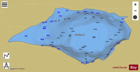
Lake Engstlen Fishing Map Stats | |
| Title | Lake Engstlen |
| Scale | 1:6000 |
| Area * | 113.16 acres |
| Shoreline * | 2.03 miles |
| Min Longitude | 8.35 |
| Min Latitude | 46.77 |
| Max Longitude | 8.36 |
| Max Latitude | 46.78 |
| Edition Label 1 | |
| Edition Label 2 | |
| Edition Label 3 | |
| Id | II_CH_eu_ch_be_io_engstlen_licc |
| Country | Inland Europe |
| Projection | Mercator |
| * some Stats may include nearby/connecting waterbodies | |
|