Black Lake fishing map is included in Saskatchewan Fishing Maps nautical charts folio. It is available as part of iBoating : Canada Marine & Fishing App (now supported on multiple platforms including Android, iPhone/iPad, MacBook, and Windows(tablet and phone)/PC based chartplotter. ).
With our Lake Maps App, you get all the great marine chart app features like fishing spots, along with Black Lake depth map. The fishing maps app include HD lake depth contours, along with advanced features found in Fish Finder / Gps Chart Plotter systems, turning your device into a Depth Finder. The Black Lake Navigation App provides advanced features of a Marine Chartplotter including adjusting water level offset and custom depth shading. Fishing spots and depth contours layers are available in most Lake maps. Lake navigation features include advanced instrumentation to gather wind speed direction, water temperature, water depth, and accurate GPS with AIS receivers(using NMEA over TCP/UDP). Autopilot support can be enabled during ‘Goto WayPoint’ and ‘Route Assistance’.
Now i-Boating supports Fishing Points in Black Lake.
Have more questions about the Nautical Chart App? Ask us.
Fishing Info for Black Lake
Black Lake is a lake in the Mackenzie River drainage basin in northern Saskatchewan, Canada. It is about 55 kilometres (34 mi) long, 17 kilometres (11 mi) wide, has an area of 464 square kilometres (179 sq mi), and lies at an elevation of 281 metres (922 ft). The primary inflows are the Chipman River, Cree River, Fond du Lac River, and Souter River; the primary outflow is Fond du Lac River, which flows via the Mackenzie River into the Arctic Ocean. The community of Black Lake is located on the northwest shore of the lake, near where the Fond du Lac River exits.
More on Wikipedia...Popular fish species in this lake include Arctic grayling, Burbot, Cisco (fish), Lake trout, Lake whitefish, Longnose sucker, Northern pike, Walleye, White sucker and Yellow perch.
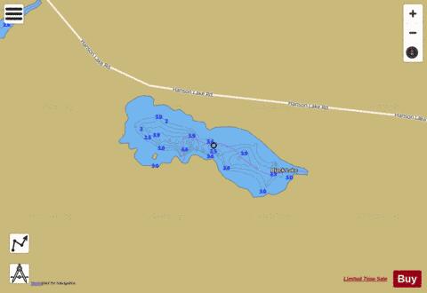
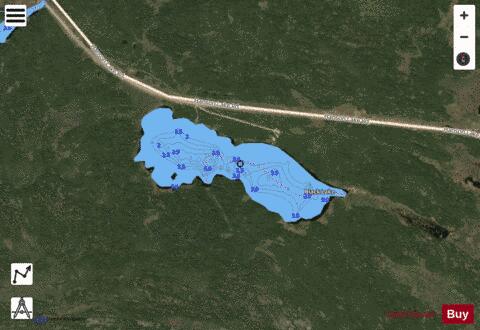
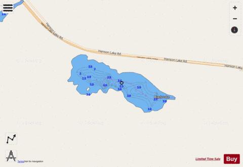
Black Lake Fishing Map Stats | |
| Title | Black Lake |
| Scale | 1:6000 |
| Nearby Cities | Flin Flon, Flin Flon, Pelican Narrows |
| Area * | 84.68 acres |
| Shoreline * | 2.17 miles |
| Min Longitude | -102.03 |
| Min Latitude | 54.82 |
| Max Longitude | -102.01 |
| Max Latitude | 54.82 |
| Edition Label 1 | |
| Edition Label 2 | |
| Edition Label 3 | |
| Id | CA_SK_Black_Lake_sk |
| Country | CA |
| Projection | Mercator |
| * some Stats may include nearby/connecting waterbodies | |
|