Pierre-Paul, Lac fishing map is included in Quebec to Anticosti Island West nautical charts folio. It is available as part of iBoating : Canada Marine & Fishing App (now supported on multiple platforms including Android, iPhone/iPad, MacBook, and Windows(tablet and phone)/PC based chartplotter. ).
With our Lake Maps App, you get all the great marine chart app features like fishing spots, along with Pierre-Paul, Lac depth map. The fishing maps app include HD lake depth contours, along with advanced features found in Fish Finder / Gps Chart Plotter systems, turning your device into a Depth Finder. The Pierre-Paul, Lac Navigation App provides advanced features of a Marine Chartplotter including adjusting water level offset and custom depth shading. Fishing spots and depth contours layers are available in most Lake maps. Lake navigation features include advanced instrumentation to gather wind speed direction, water temperature, water depth, and accurate GPS with AIS receivers(using NMEA over TCP/UDP). Autopilot support can be enabled during ‘Goto WayPoint’ and ‘Route Assistance’.
Now i-Boating supports Fishing Points in Pierre-Paul, Lac.
Have more questions about the Nautical Chart App? Ask us.
Fishing Info for Pierre-Paul, Lac
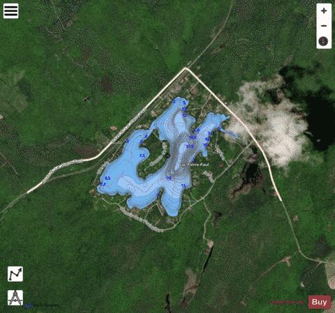
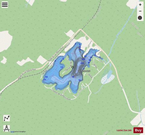
The Lake Pierre-Paul is located at Saint-Tite in Mékinac Regional County Municipality, in the administrative region of Mauricie, in the province of Quebec, Canada. This lake is part of the Batiscanie watershed. From St. Joseph Boulevard in Saint-Tite, taking the road of Lake Pierre-Paul (along the CN railroad), just browse 1.4 km to cross (on the right) the road "Petit Pierre-Paul", 2.2 km to reach the lake Pierre-Paul, 2.4 km to reach the intersection of "chemin de l'île" (Road island), and 3.6 km to the corner of the road that branches off to the right (Saint-Adelphe) and crosses the railway. The lake is bordered on the northwest by the route of the CNR Railway, which connects Saint-Tite and Sainte-Thècle. Lake Pierre-Paul Road and a road used to go around the lake. Lake Pierre-Paul is characterized by an island (shaped as a moccasin) located in the center and accessible via a bridge connecting it to the north shore. The surface of the lake is 150 meters above sea level. Its mouth is located in the north-east of the lake and outlet flows into a small lake. The outlet of this small lake is the Pierre-Paul River whose path is shaped like a giant "Z", flowing straight north into Sainte-Thècle and Saint-Adelphe. Today, the area around the Pierre-Paul lake is characterized by its highly developed resort. The area north of Pierre-Paul lake had been cleared at the end of the XIXth and early XXth, then soil cultivation has been abandoned for reforestation. Formerly, the Charest road (designated as a tribute to Florent Charest, whose family lived in Sainte-Thècle at the corner of St Thomas Road and Rompré road), the road linking St Thomas Road to Pierre-Paul lake (in Saint-Tite), a segment of about 1.2 km from the road was abandoned in the 1970s, starting with lake Road Pierre-Paul.
More on Wikipedia...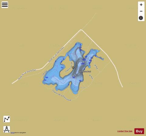
Pierre-Paul, Lac Fishing Map Stats | |
| Title | Pierre-Paul, Lac |
| Scale | 1:6000 |
| Districts | Mékinac |
| Nearby Cities | Saint-Tite, Sainte-Thècle, Shawinigan, Notre-Dame-du-Mont-Carmel, Trois-Rivières, Saint-Boniface, Gentilly, Saint-Marc-des-Carrières, Godefroy, Saint Grégoire |
| Area * | 151.81 acres |
| Shoreline * | 4.34 miles |
| Min Longitude | -72.52 |
| Min Latitude | 46.74 |
| Max Longitude | -72.50 |
| Max Latitude | 46.75 |
| Edition Label 1 | |
| Edition Label 2 | |
| Edition Label 3 | |
| Id | CA_QC_V_01595 |
| Country | CA |
| Projection | Mercator |
| * some Stats may include nearby/connecting waterbodies | |
| |||||||||||||||||||||||||||||||||||||||||||||||||||||||||||||||||||||||||||||||||||||||||||||||||||||||
|