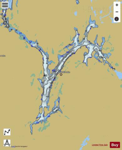
Rabbit Lake fishing map is included in Ontario Lakes nautical charts folio. It is available as part of iBoating : Canada Marine & Fishing App (now supported on multiple platforms including Android, iPhone/iPad, MacBook, and Windows(tablet and phone)/PC based chartplotter. ).
With our Lake Maps App, you get all the great marine chart app features like fishing spots, along with Rabbit Lake depth map. The fishing maps app include HD lake depth contours, along with advanced features found in Fish Finder / Gps Chart Plotter systems, turning your device into a Depth Finder. The Rabbit Lake Navigation App provides advanced features of a Marine Chartplotter including adjusting water level offset and custom depth shading. Fishing spots and depth contours layers are available in most Lake maps. Lake navigation features include advanced instrumentation to gather wind speed direction, water temperature, water depth, and accurate GPS with AIS receivers(using NMEA over TCP/UDP). Autopilot support can be enabled during ‘Goto WayPoint’ and ‘Route Assistance’.
Now i-Boating supports Fishing Points in Rabbit Lake.
Have more questions about the Nautical Chart App? Ask us.
Fishing Info for Rabbit Lake
Rabbit Lake (known as "Waw-bos Nah-mat-ta-bee" in Ojibway) is a lake in the Temagami region of Northeastern Ontario, Canada, and lies within the townships of Askin, Riddell, and Eldridge. The lake is the largest and southernmost in a chain of lakes including Cassels Lake, Snake Island Lake, and . Rabbit Lake was an important trade route to the Natives, and even saw a fight or two. There is a story about a short fight involving Temagami natives and Iroquois. The story goes that there were some Iroquois camping on an island on the lake, and at night some "Temagami's" went ashore and slit the bottoms of their canoes. The next morning the Iroquois were picked off one by one as their canoes sank in the water. The forest surrounding the lake has been actively logged since the early 20th century, and is most noticeable north of Rabbit Point where the forest still has not fully grown back after nearly a century. On the western shore just north of Rabbit Point, lies a 491 hectare area that has never been touched by logging, and has become the Rabbit Lake West Conservation Reserve. The reserve is the least known and the most untouched of its kind in Ontario. This old growth stand is closer to the original Temagami Boreal forest than even the White Bear Forest to the north. Like the other lakes in the region, Rabbit Lake is an oligotrophic ecosystem. While the fish population has steadily declined over the years, the lake is still home to pike, walleye, trout, whitefish, perch, bass, etc. Hollywood has also visited the lake when scenes from the James Cagney movie "Captains of the Clouds" were filmed at Matabitchuan Lodge, a wilderness lodge in the north-east bay, on Rabbit Lake. Props from the movie can be seen on display in the lodge. This movie was also the first Hollywood movie to be filmed entirely on location in Canada.
More on Wikipedia...Popular fish species in this lake include Esox, Freshwater whitefish and Walleye.
Rabbit Lake Fishing Map Stats | |
| Title | Rabbit Lake |
| Scale | 1:24000 |
| Districts | Nipissing |
| Nearby Cities | Ville-Marie, Cobalt, Haileybury, New Liskeard, Témiscaming, Sturgeon Falls, North Bay, Englehart, Powassan |
| Area * | 5238.23 acres |
| Shoreline * | 81.78 miles |
| Min Longitude | -79.72 |
| Min Latitude | 46.93 |
| Max Longitude | -79.56 |
| Max Latitude | 47.05 |
| Edition Label 1 | |
| Edition Label 2 | |
| Edition Label 3 | |
| Id | CA_ON_V_103381051 |
| Country | CA |
| Projection | Mercator |
| * some Stats may include nearby/connecting waterbodies | |
|


