Sandy Lake fishing map is included in Ontario Lakes nautical charts folio. It is available as part of iBoating : Canada Marine & Fishing App (now supported on multiple platforms including Android, iPhone/iPad, MacBook, and Windows(tablet and phone)/PC based chartplotter. ).
With our Lake Maps App, you get all the great marine chart app features like fishing spots, along with Sandy Lake depth map. The fishing maps app include HD lake depth contours, along with advanced features found in Fish Finder / Gps Chart Plotter systems, turning your device into a Depth Finder. The Sandy Lake Navigation App provides advanced features of a Marine Chartplotter including adjusting water level offset and custom depth shading. Fishing spots and depth contours layers are available in most Lake maps. Lake navigation features include advanced instrumentation to gather wind speed direction, water temperature, water depth, and accurate GPS with AIS receivers(using NMEA over TCP/UDP). Autopilot support can be enabled during ‘Goto WayPoint’ and ‘Route Assistance’.
Now i-Boating supports Fishing Points in Sandy Lake.
Have more questions about the Nautical Chart App? Ask us.
Fishing Info for Sandy Lake
Sandy Lake is a lake in Trent Lakes township, Peterborough County, Ontario, Canada. It is about 5 km west of the community of Buckhorn, 1 km east of Lakehurst, and 25 km north of Peterborough. The lake is typically clear of turbidity and has a slight green color which results from the minerals present in the spring-fed water that feeds the lake. A small creek connects Sandy Lake to the Trent-Severn waterway at Buckhorn Lake. The majority of residences are seasonal.
More on Wikipedia...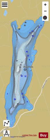
Sandy Lake Fishing Map Stats | |
| Title | Sandy Lake |
| Scale | 1:12000 |
| Districts | Peterborough |
| Nearby Cities | Bobcaygeon, Bridgenorth - Chemong Park Area, Lakefield, Peterborough, Omemee, Fenelon Falls, Lindsay, Millbrook, Norwood, Hastings |
| Area * | 889.12 acres |
| Shoreline * | 8.66 miles |
| Min Longitude | -78.41 |
| Min Latitude | 44.52 |
| Max Longitude | -78.39 |
| Max Latitude | 44.56 |
| Edition Label 1 | |
| Edition Label 2 | |
| Edition Label 3 | |
| Id | CA_ON_R_103384139 |
| Country | CA |
| Projection | Mercator |
| * some Stats may include nearby/connecting waterbodies | |
|