Grimsthorpe Lake fishing map is included in Ontario Lakes nautical charts folio. It is available as part of iBoating : Canada Marine & Fishing App (now supported on multiple platforms including Android, iPhone/iPad, MacBook, and Windows(tablet and phone)/PC based chartplotter. ).
With our Lake Maps App, you get all the great marine chart app features like fishing spots, along with Grimsthorpe Lake depth map. The fishing maps app include HD lake depth contours, along with advanced features found in Fish Finder / Gps Chart Plotter systems, turning your device into a Depth Finder. The Grimsthorpe Lake Navigation App provides advanced features of a Marine Chartplotter including adjusting water level offset and custom depth shading. Fishing spots and depth contours layers are available in most Lake maps. Lake navigation features include advanced instrumentation to gather wind speed direction, water temperature, water depth, and accurate GPS with AIS receivers(using NMEA over TCP/UDP). Autopilot support can be enabled during ‘Goto WayPoint’ and ‘Route Assistance’.
Now i-Boating supports Fishing Points in Grimsthorpe Lake.
Have more questions about the Nautical Chart App? Ask us.
Fishing Info for Grimsthorpe Lake
Grimsthorpe Lake is a lake in the Moira River and Lake Ontario drainage basins that straddles the border between Tweed, Hastings County and Addington Highlands, Lennox and Addington County in Ontario, Canada. The lake is about 1.9 kilometres (1.2 mi) long and 0.9 kilometres (0.6 mi) wide and lies at an elevation of 319 metres (1,047 ft) about 11 kilometres (7 mi) east of the community of Gunter and 17 kilometres (11 mi) northwest of the community of Cloyne. The primary inflow is Partridge Creek from the northwest, and there are three unnamed creek secondary inflows at the southwest, north and south. Partridge Creek is also the primary outflow at the southeast. It flows via the Skootamatta River and Moira River into the Bay of Quinte on Lake Ontario at Belleville.
More on Wikipedia...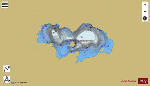
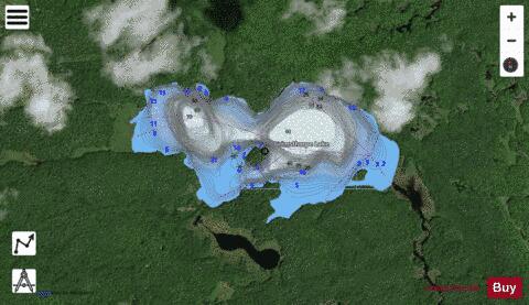
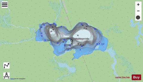
Grimsthorpe Lake Fishing Map Stats | |
| Title | Grimsthorpe Lake |
| Scale | 1:12000 |
| Districts | Hastings, Lennox and Addington |
| Nearby Cities | Madoc, Tweed, Marmora, Stirling, Havelock, Barry's Bay, Campbellford, Frankford, Belleville, Eganville |
| Area * | 228.48 acres |
| Shoreline * | 4.04 miles |
| Min Longitude | -77.41 |
| Min Latitude | 44.87 |
| Max Longitude | -77.38 |
| Max Latitude | 44.88 |
| Edition Label 1 | |
| Edition Label 2 | |
| Edition Label 3 | |
| Id | CA_ON_grimsthorpe_lake__on |
| Country | CA |
| Projection | Mercator |
| * some Stats may include nearby/connecting waterbodies | |
|