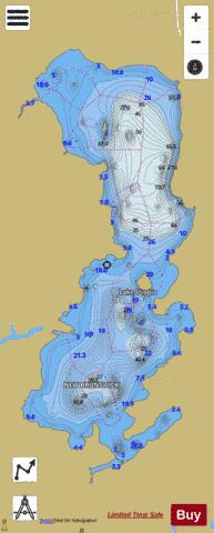
Lake Utopia fishing map is included in New Brunswick Fishing Maps nautical charts folio. It is available as part of iBoating : Canada Marine & Fishing App (now supported on multiple platforms including Android, iPhone/iPad, MacBook, and Windows(tablet and phone)/PC based chartplotter. ).
With our Lake Maps App, you get all the great marine chart app features like fishing spots, along with Lake Utopia depth map. The fishing maps app include HD lake depth contours, along with advanced features found in Fish Finder / Gps Chart Plotter systems, turning your device into a Depth Finder. The Lake Utopia Navigation App provides advanced features of a Marine Chartplotter including adjusting water level offset and custom depth shading. Fishing spots and depth contours layers are available in most Lake maps. Lake navigation features include advanced instrumentation to gather wind speed direction, water temperature, water depth, and accurate GPS with AIS receivers(using NMEA over TCP/UDP). Autopilot support can be enabled during ‘Goto WayPoint’ and ‘Route Assistance’.
Now i-Boating supports Fishing Points in Lake Utopia.
Have more questions about the Nautical Chart App? Ask us.
Fishing Info for Lake Utopia
Lake Utopia is located in eastern Charlotte County, New Brunswick. The southern shore of the lake is one kilometre northeast of the town of St. George. The lake is connected to the Magaguadavic River by the second deepest in the world. Lake Utopia is approximately 7 kilometres long and between 0.8 and 2.8 kilometres in width. The lake level varies throughout the year, as more or less water is allowed through a hydroelectric dam on the Magaguadavic River in St. George. The lake is surrounded by mixed Acadian forest and its shoreline has been traditionally dotted by both rustic camps and large summer homes however over the last decade an increase in year-round home development has occurred. The lake has six islands which are privately owned and situated with seasonal cottages. During the winter months, much of the lake completely freezes. Lake Utopia is a popular eastern Charlotte County recreation destination among year-round residents and cottage-goers for swimming, boating and fishing. Fish in the lake include smallmouth bass, trout, perch and . On the western side of the lake is Canal Beach. Canal Beach is the major swimming destination on the lake's western shore. Its natural sand occupies a 0.5 kilometre stretch of shoreline. The beach/park is maintained and operated by the Town of St. George, and is open from the first weekend of June to weekend after Labour Day. Despite being a public beach, there is no lifeguard on duty. Canal Beach is equipped with a beach volleyball court, playground, seasonal canteen, washrooms and changing rooms. Immediately north of Canal Beach is the natural canal that connects the lake to the Magaguadavic River. Further north, still on the western shore of the lake, is Grey Mountain. Much of the northern area of the lake's western shore is untouched with only a few cottages. On the northern shore of the lake was a smaller, less popular swimming location called "Scout's Beach" (also traditionally called "Frauley's Beach"). During the 1940s-1960s, a Scouts Canada camp was built on the north shore of the lake. The camp was later owned and maintained by Connors Bros. Ltd. After the decline of its operation, Scout's Beach became known locally as a "party spot" and was host to two or three large gatherings every summer during the 1970s-1980s. In the early 2000s, the land was sold by Connors Bros. Ltd. to a private developer and a number of homes were constructed, including a very large private estate. The beach area is now private, restricted to public use. On the lake's eastern shore, near a spot locally known as "the Bluff", during the early 1900s, "Bryn Derwyn", a summer hotel which was later a summer camp for boys operated until it burned in June 1918. The boys camp continued through the 1920s. During the 1960s, local company Connors Bros. Ltd., who owned much of the eastern shore at that time, operated a public beach. The beach was a popular spot with concession stands and amusement rides. Much of the lake's eastern shore is developed with both cottages and year-round homes, and connected via Route 785.
More on Wikipedia...Popular fish species in this lake include Connors Brothers Limited and Smallmouth bass.
Lake Utopia Fishing Map Stats | |
| Title | Lake Utopia |
| Scale | 1:24000 |
| Nearby Cities | Saint Andrews, St. Stephen, Starlight Village, Saint John, Oromocto, New Maryland, Fredericton, Quispamsis - Rothesay, Wells |
| Area * | 3429.34 acres |
| Shoreline * | 24.63 miles |
| Min Longitude | -66.82 |
| Min Latitude | 45.14 |
| Max Longitude | -66.77 |
| Max Latitude | 45.21 |
| Edition Label 1 | |
| Edition Label 2 | |
| Edition Label 3 | |
| Id | CA_NB_utopia_nb |
| Country | CA |
| Projection | Mercator |
| * some Stats may include nearby/connecting waterbodies | |
| ||||||||||||||||||||||||||||||||||||||||||||||||||||||||||||||||||||||||||||||||||||||||||||||||||||||||
|


