Seton Lake fishing map is included in Lakes and Rivers of British Columbia nautical charts folio. It is available as part of iBoating : Canada Marine & Fishing App (now supported on multiple platforms including Android, iPhone/iPad, MacBook, and Windows(tablet and phone)/PC based chartplotter. ).
With our Lake Maps App, you get all the great marine chart app features like fishing spots, along with Seton Lake depth map. The fishing maps app include HD lake depth contours, along with advanced features found in Fish Finder / Gps Chart Plotter systems, turning your device into a Depth Finder. The Seton Lake Navigation App provides advanced features of a Marine Chartplotter including adjusting water level offset and custom depth shading. Fishing spots and depth contours layers are available in most Lake maps. Lake navigation features include advanced instrumentation to gather wind speed direction, water temperature, water depth, and accurate GPS with AIS receivers(using NMEA over TCP/UDP). Autopilot support can be enabled during ‘Goto WayPoint’ and ‘Route Assistance’.
Now i-Boating supports Fishing Points in Seton Lake.
Have more questions about the Nautical Chart App? Ask us.
Fishing Info for Seton Lake
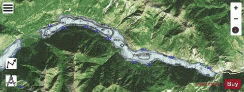
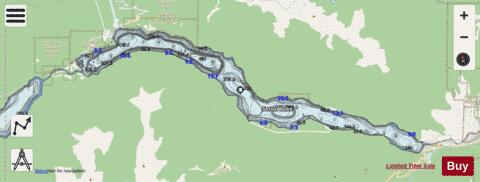
Seton Lake is a freshwater fjord draining east via the Seton River into the Fraser River at the town of Lillooet, about 22 km (14 mi) long, 26.2 km2 (10.1 sq mi) in area and lies at an elevation of 243 m (797 ft). Its depth is 460 m (1,500 ft). The lake is natural in origin but was raised slightly as part of the Bridge River Power Project, the two main powerhouses of which are on the north shore of the upper end of the lake near Shalalth. At the uppermost end of the lake is the community of Seton Portage and the mouth of the short Seton Portage River, which connects Anderson Lake on the farther side of the Portage to Seton Lake. The Seton Portage River is the main source of natural inflow to Seton Lake, and is primarily fed by Anderson Lake but also by Whitecap Creek, which has its origin on the east slopes of Whitecap Mountain, the highest in the Bendor Range, and by Spider Creek, which has its origin on the north slopes of an unnamed summit to the south of Seton Lake, which happens to be the highest of the Cayoosh Range which lines the south flank of the valley. The Canadian National Railway (formerly the British Columbia Railway, originally the Pacific Great Eastern) runs along the north shore of the lake. Prior to the construction of the power project, Seton was considered the bluer and clearer and more brilliant of the two lakes. Afterwards, diversion of the glacial silt-laden waters of the Bridge River into Seton Lake have transformed it into a dull turquoise, and Anderson is now considered the bluer of the two lakes. The lake was named in the 1860s by Alexander Caulfield Anderson, who traversed the uncharted territory in 1846, after his cousin and boyhood friend, Lt. Col. Alexander Seton, who was drowned in the wreck of the troopship HMS Birkenhead off the South African coast in 1852. In 1858 the route of the Douglas Road incorporated the lake passage.
More on Wikipedia...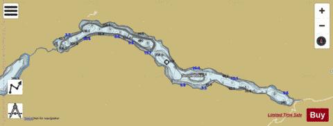
Seton Lake Fishing Map Stats | |
| Title | Seton Lake |
| Scale | 1:24000 |
| Districts | Squamish-Lillooet |
| Nearby Cities | Lillooet, Pemberton, Ashcroft, Whistler |
| Area * | 6207.02 acres |
| Shoreline * | 36.27 miles |
| Min Longitude | -122.30 |
| Min Latitude | 50.66 |
| Max Longitude | -121.98 |
| Max Latitude | 50.73 |
| Edition Label 1 | |
| Edition Label 2 | |
| Edition Label 3 | |
| Id | CA_BC_seton_lake_bc |
| Country | CA |
| Projection | Mercator |
| * some Stats may include nearby/connecting waterbodies | |
|