Green Lake fishing map is included in Lakes and Rivers of British Columbia nautical charts folio. It is available as part of iBoating : Canada Marine & Fishing App (now supported on multiple platforms including Android, iPhone/iPad, MacBook, and Windows(tablet and phone)/PC based chartplotter. ).
With our Lake Maps App, you get all the great marine chart app features like fishing spots, along with Green Lake depth map. The fishing maps app include HD lake depth contours, along with advanced features found in Fish Finder / Gps Chart Plotter systems, turning your device into a Depth Finder. The Green Lake Navigation App provides advanced features of a Marine Chartplotter including adjusting water level offset and custom depth shading. Fishing spots and depth contours layers are available in most Lake maps. Lake navigation features include advanced instrumentation to gather wind speed direction, water temperature, water depth, and accurate GPS with AIS receivers(using NMEA over TCP/UDP). Autopilot support can be enabled during ‘Goto WayPoint’ and ‘Route Assistance’.
Now i-Boating supports Fishing Points in Green Lake.
Have more questions about the Nautical Chart App? Ask us.
Fishing Info for Green Lake
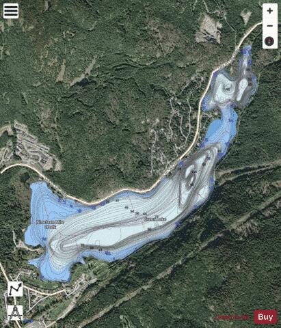
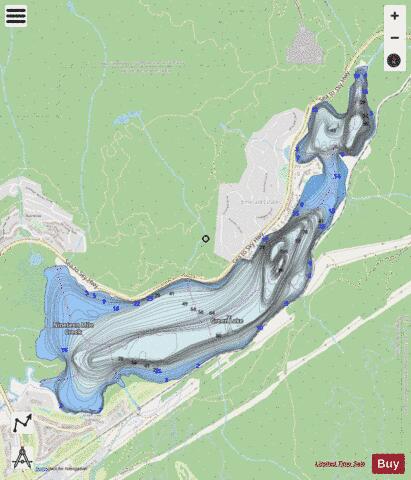
Green Lake is the largest and most northerly lake in the Resort Municipality of Whistler, British Columbia, Canada. It is the source of the Green River, a tributary of the Lillooet River, and is fed by the River of Golden Dreams, which issues from Alta Lake, which is at the height of land dividing the Green River drainage from that of the Cheakamus River to the south, which is a tributary of the Squamish River. Also feeding Green Lake are Fitzsimmons Creek, which originates in the valley above Whistler Village between Blackcomb and Whistler Mountains, and Rainbow Creek, which descends from Rainbow Mountain via the Alpine Meadows subdivision. A former minor ski hill, Rainbow , is located midway between Alpine Meadows and Emerald Estates near the lake's western extremity. The Whistler neighbourhoods of and are located on the lake's southwestern and northwestern shores, respectively. The ghost town of (aka , though that is a rail stop at the outlet of Green Lake about 1 km north), is known locally but incorrectly as . (The Soo Valley, while nearby, is in a different drainage). Parkhurst grew up around a lumber mill on a point on the east shore of the lake at its narrowest point, opposite Emerald Estates; the porch of the old main building was the location of a locally famous group nude photo by squatter residents of the area in the 1970s, many of whom now figure in the Whistler establishment. Green Lake is 633 m in elevation, approximately 1.2 km in length, and averages about 650 m in width—with an area in the range of 2.2 km2. Green Lake also serves as Whistler Airport (airport code YWS), a waterdrome.
More on Wikipedia...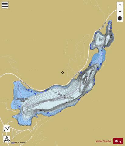
Green Lake Fishing Map Stats | |
| Title | Green Lake |
| Scale | 1:12000 |
| Districts | Squamish-Lillooet |
| Nearby Cities | Whistler, Pemberton, Squamish, Lions Bay, Miller's Landing, Gibsons, Vancouver |
| Area * | 494.11 acres |
| Shoreline * | 6.84 miles |
| Min Longitude | -122.96 |
| Min Latitude | 50.14 |
| Max Longitude | -122.92 |
| Max Latitude | 50.17 |
| Edition Label 1 | |
| Edition Label 2 | |
| Edition Label 3 | |
| Id | CA_BC_green_lake__bc |
| Country | CA |
| Projection | Mercator |
| * some Stats may include nearby/connecting waterbodies | |
| ||||||||||||||||||||||||||||||||||||||||||||||||||||||||||||||||||||||||||||||||||||||||||||||||||||||||
|