Cameron Lake fishing map is included in Lakes and Rivers of British Columbia nautical charts folio. It is available as part of iBoating : Canada Marine & Fishing App (now supported on multiple platforms including Android, iPhone/iPad, MacBook, and Windows(tablet and phone)/PC based chartplotter. ).
With our Lake Maps App, you get all the great marine chart app features like fishing spots, along with Cameron Lake depth map. The fishing maps app include HD lake depth contours, along with advanced features found in Fish Finder / Gps Chart Plotter systems, turning your device into a Depth Finder. The Cameron Lake Navigation App provides advanced features of a Marine Chartplotter including adjusting water level offset and custom depth shading. Fishing spots and depth contours layers are available in most Lake maps. Lake navigation features include advanced instrumentation to gather wind speed direction, water temperature, water depth, and accurate GPS with AIS receivers(using NMEA over TCP/UDP). Autopilot support can be enabled during ‘Goto WayPoint’ and ‘Route Assistance’.
Now i-Boating supports Fishing Points in Cameron Lake.
Have more questions about the Nautical Chart App? Ask us.
Fishing Info for Cameron Lake
Cameron Lake is a lake in central Vancouver Island located 15 km east of Port Alberni, on the north side of Highway 4. It has an area of 477 hectares and an elevation of 184 metres above sea level. The lake is between Mount Arrowsmith to the south and Mount Wesley to the north. The lake was named by Captain Richards in 1860 for David Cameron, the first Chief Justice of Vancouver Island. The entire southern shore of the lake is incorporated in the Little Qualicum Falls Provincial Park A popular folktale is that a train came crashing down the mountain from the Island Rail Corridor, this however is false. Reports of peculiar sightings in the lake's waters and the local legend of resident lake monster, nicknamed Cammie, remain popular. In the summer of 2009, the B.C. Cryptozoology Club was not able to identify the source of earlier sightings of what may have been a large trout or something larger leading to speculation about some sort of sea serpent. In February 2016 researcher John Kirk and his team detected something big in the water, however, their underwater camera became detached. Kirk speculates the mysterious lake creature could be a giant sturgeon, a huge eel or a massive salamander.
More on Wikipedia...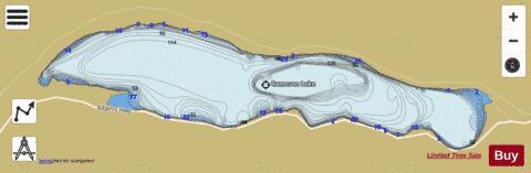
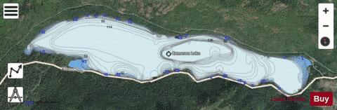
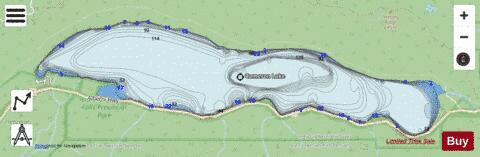
Cameron Lake Fishing Map Stats | |
| Title | Cameron Lake |
| Scale | 1:12000 |
| Districts | Nanaimo |
| Nearby Cities | Port Alberni, Parksville, Courtenay, Fairwinds, Cumberland, Puntledge, Powell River, Nanaimo, Lake Cowichan, Welcome Beach |
| Area * | 1083.56 acres |
| Shoreline * | 8.44 miles |
| Min Longitude | -124.66 |
| Min Latitude | 49.29 |
| Max Longitude | -124.59 |
| Max Latitude | 49.30 |
| Edition Label 1 | |
| Edition Label 2 | |
| Edition Label 3 | |
| Id | CA_BC_cameron_lake__bc |
| Country | CA |
| Projection | Mercator |
| * some Stats may include nearby/connecting waterbodies | |
| |||||||||||||||||||||||||||||||||||||||||||||||||||||||||||||||||||||||||||||||||||||||||||||||||||||||
|