Alta Lake fishing map is included in Lakes and Rivers of British Columbia nautical charts folio. It is available as part of iBoating : Canada Marine & Fishing App (now supported on multiple platforms including Android, iPhone/iPad, MacBook, and Windows(tablet and phone)/PC based chartplotter. ).
With our Lake Maps App, you get all the great marine chart app features like fishing spots, along with Alta Lake depth map. The fishing maps app include HD lake depth contours, along with advanced features found in Fish Finder / Gps Chart Plotter systems, turning your device into a Depth Finder. The Alta Lake Navigation App provides advanced features of a Marine Chartplotter including adjusting water level offset and custom depth shading. Fishing spots and depth contours layers are available in most Lake maps. Lake navigation features include advanced instrumentation to gather wind speed direction, water temperature, water depth, and accurate GPS with AIS receivers(using NMEA over TCP/UDP). Autopilot support can be enabled during ‘Goto WayPoint’ and ‘Route Assistance’.
Now i-Boating supports Fishing Points in Alta Lake.
Have more questions about the Nautical Chart App? Ask us.
Fishing Info for Alta Lake
Alta Lake is a lake in the Resort Municipality of Whistler, British Columbia, Canada. Originally named Summit Lake, Alta Lake was renamed to avoid confusion with the many other Summit Lakes in British Columbia. The name is derived from the Spanish for "high up" or "upper". The lake's southern end is the divide between the basins of the Green and Cheakamus Rivers. The lake is 642 m (2,106 ft) in elevation and approximately 1.1 km2 (0.42 sq mi) in area and 2.2 km (1.4 mi) north to south, with a maximum width of about 675 metres (2,215 ft), east to west. Neighbourhoods around the lake include Alta Lake, the original community in this area (now referred to as "Westside"), Alta Vista and Whistler Cay Estates. At the north end of the lake the original site of Rainbow Lodge preserves some cabins that were part of that rustic resort, and a municipally run ecological preserve which extends up the wetlands of the River of Golden Dreams (aka Alta Creek), which leads to Green Lake. A wayside park, formerly a provincial park and now municipally run is located near the south end of the lake.
More on Wikipedia...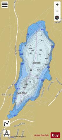
Alta Lake Fishing Map Stats | |
| Title | Alta Lake |
| Scale | 1:12000 |
| Districts | Squamish-Lillooet |
| Nearby Cities | Whistler, Pemberton, Squamish, Lions Bay, Miller's Landing, Gibsons, Vancouver, Roberts Creek, Sechelt |
| Area * | 256.69 acres |
| Shoreline * | 3.51 miles |
| Min Longitude | -122.99 |
| Min Latitude | 50.10 |
| Max Longitude | -122.97 |
| Max Latitude | 50.12 |
| Edition Label 1 | |
| Edition Label 2 | |
| Edition Label 3 | |
| Id | CA_BC_CA_BC_Alta |
| Country | CA |
| Projection | Mercator |
| * some Stats may include nearby/connecting waterbodies | |
| |||||||||||||||||||||||||||||||||||||||||||||||||||||||||||||||||||||||||||||||||||||||||||||||||||||||
|