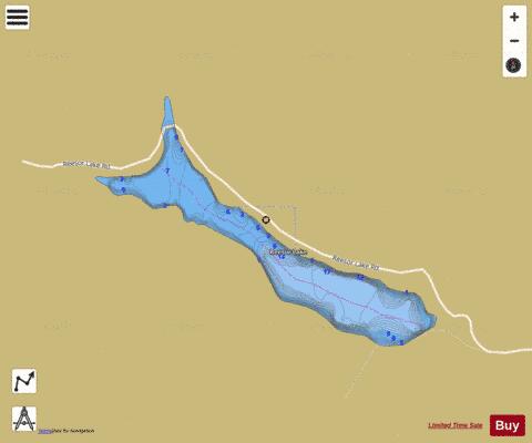
Reesor lake fishing map is included in Alberta Lakes nautical charts folio. It is available as part of iBoating : Canada Marine & Fishing App (now supported on multiple platforms including Android, iPhone/iPad, MacBook, and Windows(tablet and phone)/PC based chartplotter. ).
With our Lake Maps App, you get all the great marine chart app features like fishing spots, along with Reesor lake depth map. The fishing maps app include HD lake depth contours, along with advanced features found in Fish Finder / Gps Chart Plotter systems, turning your device into a Depth Finder. The Reesor lake Navigation App provides advanced features of a Marine Chartplotter including adjusting water level offset and custom depth shading. Fishing spots and depth contours layers are available in most Lake maps. Lake navigation features include advanced instrumentation to gather wind speed direction, water temperature, water depth, and accurate GPS with AIS receivers(using NMEA over TCP/UDP). Autopilot support can be enabled during ‘Goto WayPoint’ and ‘Route Assistance’.
Now i-Boating supports Fishing Points in Reesor lake.
Have more questions about the Nautical Chart App? Ask us.
Fishing Info for Reesor lake
Reesor Lake is a lake in Cypress Hills Provincial Park, in Alberta.Reesor Lake is a small, popular trout-fishing reservoir located within Cypress Hills Provincial Park in the Municipal District of Cypress. It was named after David William Reesor, the son of Senator David Reesor, who settled in the area in 1900. The original Reesor ranch house still stands near the shore (Alta. Cult. Multicult. n.d.). Prior to 1960, the lake was two small, separate water bodies, called Twin Lakes. In 1960, a dam was constructed across the southeast end of the valley where the two lakes were located. Water was diverted into the reservoir from Battle Creek, raising the water level and thus creating a single lake. Cypress Hills Provincial Park is situated approximately 65 km southeast of Medicine Hat, off Highway 41. Of the 12 campgrounds in the park, two are located near Reesor Lake. The first of these is Reesor Lake Dock Campground, which is situated on the north shore of the lake off the Reesor Lake Road. It is open year-round and has 24 random campsites, a water pump, a fishing pier and a boat launch. The second campground, Reesor Lake Campground, is located south of the lake on the south side of Battle Creek. It is open from May to September and provides 40 campsites, including 7 walk-in tenting sites, tap water, picnic tables, a picnic shelter, a playground and weekly interpretive programs. A boat launch is located at the western end of the dam. The only boat motors allowed on the lake are electric (Alta. For. Ld. Wild. 1988). * v * t * e
More on Wikipedia...Reesor lake Fishing Map Stats | |
| Title | Reesor lake |
| Scale | 1:6000 |
| Districts | Division No. 1 |
| Nearby Cities | Maple Creek, Medicine Hat, Redcliff |
| Area * | 128.74 acres |
| Shoreline * | 3.40 miles |
| Min Longitude | -110.12 |
| Min Latitude | 49.66 |
| Max Longitude | -110.09 |
| Max Latitude | 49.67 |
| Edition Label 1 | |
| Edition Label 2 | |
| Edition Label 3 | |
| Id | CA_AB_ressor_lake_ab |
| Country | CA |
| Projection | Mercator |
| * some Stats may include nearby/connecting waterbodies | |
|


