Crawling Valley Reservoir fishing map is included in Alberta Lakes nautical charts folio. It is available as part of iBoating : Canada Marine & Fishing App (now supported on multiple platforms including Android, iPhone/iPad, MacBook, and Windows(tablet and phone)/PC based chartplotter. ).
With our Lake Maps App, you get all the great marine chart app features like fishing spots, along with Crawling Valley Reservoir depth map. The fishing maps app include HD lake depth contours, along with advanced features found in Fish Finder / Gps Chart Plotter systems, turning your device into a Depth Finder. The Crawling Valley Reservoir Navigation App provides advanced features of a Marine Chartplotter including adjusting water level offset and custom depth shading. Fishing spots and depth contours layers are available in most Lake maps. Lake navigation features include advanced instrumentation to gather wind speed direction, water temperature, water depth, and accurate GPS with AIS receivers(using NMEA over TCP/UDP). Autopilot support can be enabled during ‘Goto WayPoint’ and ‘Route Assistance’.
Now i-Boating supports Fishing Points in Crawling Valley Reservoir.
Have more questions about the Nautical Chart App? Ask us.
Fishing Info for Crawling Valley Reservoir
Crawling Valley Reservoir, or Barkenhouse Lake, is a reservoir in Alberta. The reservoir uses the existing Crawling Valley, which was depression created as a meltwater channel created during the letting of the Laurentide ice sheet at the end of the last ice age. Construction of dams and canals began in 1983, diverting some water from the Bow River via the North Branch Canal, starting just upstream of the Bassano Dam (southwest of the town of Bassano, to fill the reservoir. The main drainage flowing from the Crawling Valley Reservoir flows through a continuation of the North Branch Canal, serving irrigation needs, with other outflow into the Matzhiwin Creek. * v * t * e
More on Wikipedia...
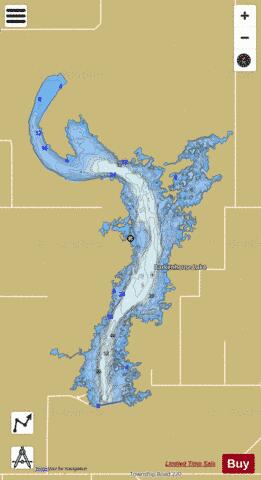

Crawling Valley Reservoir Fishing Map Stats | |
| Title | Crawling Valley Reservoir |
| Scale | 1:24000 |
| Districts | Division No. 2 |
| Nearby Cities | Bassano, Duchess, Brooks, Drumheller, Hanna, Vauxhall, Vulcan, Strathmore |
| Area * | 5724.68 acres |
| Shoreline * | 84.56 miles |
| Min Longitude | -112.42 |
| Min Latitude | 50.86 |
| Max Longitude | -112.31 |
| Max Latitude | 50.97 |
| Edition Label 1 | |
| Edition Label 2 | |
| Edition Label 3 | |
| Id | CA_AB_crawling_valley_reservoir_ab |
| Country | CA |
| Projection | Mercator |
| * some Stats may include nearby/connecting waterbodies | |
|