AU_NSW_81_Port_Hacking fishing map is included in New South Wales Fishing Maps nautical charts folio. It is available as part of iBoating : Australia Marine & Fishing App (now supported on multiple platforms including Android, iPhone/iPad, MacBook, and Windows(tablet and phone)/PC based chartplotter. ).
With our Lake Maps App, you get all the great marine chart app features like fishing spots, along with AU_NSW_81_Port_Hacking lake depth map. The fishing maps app include HD lake depth contours, along with advanced features found in Fish Finder / Gps Chart Plotter systems, turning your device into a Depth Finder. The AU_NSW_81_Port_Hacking Navigation App provides advanced features of a Marine Chartplotter including adjusting water level offset and custom depth shading. Fishing spots and depth contours layers are available in most Lake maps. Lake navigation features include advanced instrumentation to gather wind speed direction, water temperature, water depth, and accurate GPS with AIS receivers(using NMEA over TCP/UDP). Autopilot support can be enabled during ‘Goto WayPoint’ and ‘Route Assistance’.
Have more questions about the Nautical Chart App? Ask us.
Fishing Info for AU_NSW_81_Port_Hacking
Port Hacking Estuary (Aboriginal Tharawal language: Deeban), an open youthful tide dominated, drowned valley estuary, is located in southern Sydney, New South Wales, Australia approximately 30 kilometres (19 mi) south of Sydney central business district. Port Hacking has its source in the upper reaches of the Hacking River south of Helensburgh, and several smaller creeks, including South West Arm, Bundeena Creek and The Basin and flows generally to the east before reaching its mouth, the Tasman Sea, south of Cronulla and north–east of Bundeena. Its tidal effect is terminated at the weir at Audley, in the Royal National Park. The lower estuary features a substantial marine delta, which over time has prograded upstream. There is also a substantial fluvial (riverine delta) of the Hacking River at Grays Point. The two deltas are separated by a deep basin. The total catchment area of Port Hacking is approximately 165 square kilometres (64 sq mi) and the area surrounding the estuary is generally managed by Sutherland Shire Council. While the area to the north of Port Hacking is urbanised, the area to the south is relatively pristine and forms the northern boundary of the Royal National Park. The land adjacent to Port Hacking was occupied for many thousands of years by the Tharawal and Eora, both Aboriginal peoples, and their associated clans. They used the bay as an important source of food and a place for trade.
More on Wikipedia...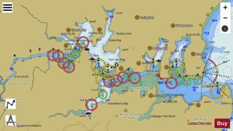
AU_NSW_81_Port_Hacking Fishing Map Stats | |
| Title | AU_NSW_81_Port_Hacking |
| Scale | 1:24000 |
| Area * | 2982.41 acres |
| Shoreline * | 46.56 miles |
| Min Longitude | 151.06 |
| Min Latitude | -34.09 |
| Max Longitude | 151.17 |
| Max Latitude | -34.04 |
| Edition Label 1 | |
| Edition Label 2 | |
| Edition Label 3 | |
| Id | AU_NSW_81_Port_Hacking |
| Country | Australia |
| Projection | Mercator |
| * some Stats may include nearby/connecting waterbodies | |
| |||||||||||||||||||||||||||||||||||||||||||||||||||||||||||||||||||||||||||||||||||||||||||||||||||||||
|