Maquan Pond fishing map is available as part of iBoating : USA Marine & Fishing App(now supported on multiple platforms including Android, iPhone/iPad, MacBook, and Windows(tablet and phone)/PC based chartplotter.).
With our Lake Maps App, you get all the great marine chart app features like fishing spots, along with Maquan Pond depth map. The fishing maps app include HD lake depth contours, along with advanced features found in Fish Finder / Gps Chart Plotter systems, turning your device into a Depth Finder. The Maquan Pond Navigation App provides advanced features of a Marine Chartplotter including adjusting water level offset and custom depth shading. Fishing spots and depth contours layers are available in most Lake maps. Lake navigation features include advanced instrumentation to gather wind speed direction, water temperature, water depth, and accurate GPS with AIS receivers(using NMEA over TCP/UDP). Autopilot support can be enabled during ‘Goto WayPoint’ and ‘Route Assistance’.
Now i-Boating supports Fishing Points in Maquan Pond.
Have more questions about the Nautical Chart App? Ask us.
Fishing Info for Maquan Pond
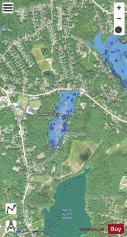
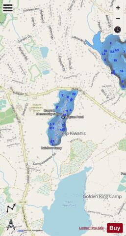
Maquan Pond is a 48-acre (190,000 m2) pond in Hanson, Massachusetts. Its average depth is 12 feet (3.7 m) and its maximum depth is 18 feet (5.5 m). The pond is spring fed with an overflow on the south end that feeds into Indian Head Pond. There has been much development along the shore. The town has a right-of-way on the northern shore of the pond off Maquan Street (Route 14). The town beach Cranberry Cove is at south end of the pond. The water is acidic, so fishing is poor except for pickerel, small yellow perch and pumpkinseeds. Camp Kiwanee, a former Camp Fire camp, is located on the southeastern shore of the pond. The town now owns the camp and rents camping and cabins as well as Needles Lodge for functions. The Rainbow Girls own land on the southwest shore and previously operated a summer camp there.
More on Wikipedia...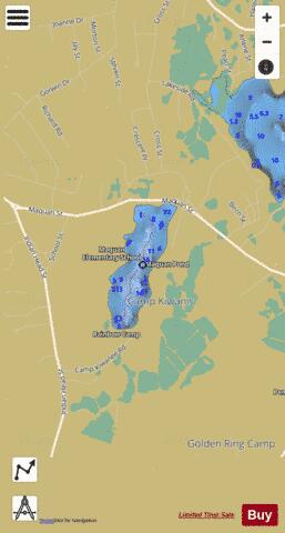
Maquan Pond Fishing Map Stats | |
| Title | Maquan Pond |
| Scale | 1:3000 |
| Counties | Plymouth |
| Nearby Cities | Hanson, Pembroke, Hanover Center, Hanover, North Pembroke, West Hanover, Halifax, North Hanover, Whitman, Rockland |
| Area * | 45.02 acres |
| Shoreline * | 1.40 miles |
| Min Longitude | -70.85 |
| Min Latitude | 42.06 |
| Max Longitude | -70.85 |
| Max Latitude | 42.06 |
| Edition Label 1 | |
| Edition Label 2 | |
| Edition Label 3 | |
| Id | US_AA_MA_maquan_pond_ma |
| Country | US |
| Projection | Mercator |
| * some Stats may include nearby/connecting waterbodies | |
|