Making Nautical Charts Easier to Read for Farsighted Boaters
Why Small Text on Nautical Charts Can Be Difficult to Read
The Farsighted Boater’s Dilemma on the Water
How Text & Icon Magnification Solves the Problem
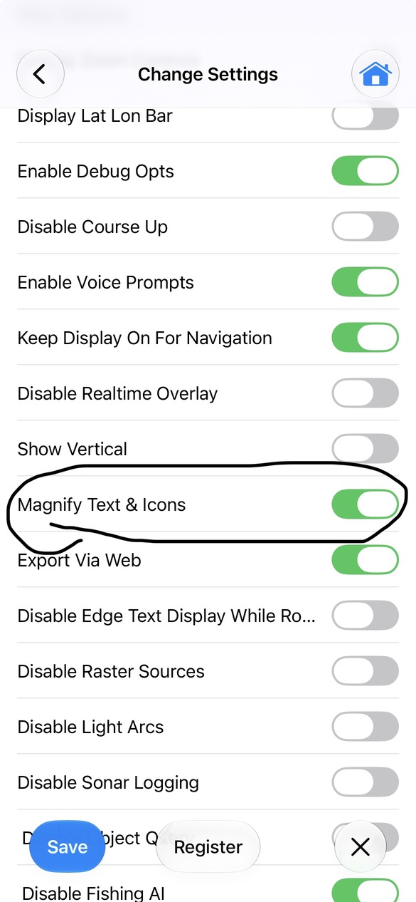
How to Enable Magnify Text and Icons
Before and After: Magnified Nautical Chart Labels
Extra Display Tips for Farsighted Navigation
Who Can Benefit From This Feature?
Does Magnify Text and Icons change the nautical chart scale?
Is this feature useful for boaters with presbyopia?
How is magnifying chart text different from zooming in?
Why Small Text on Nautical Charts Can Be Difficult to Read
For boaters who are farsighted (hyperopic/hypermetropic) or experience age-related near-vision changes (presbyopia), modern digital charts present a frustrating daily challenge: you can spot a channel marker a mile ahead on the horizon with crystal clarity, yet you cannot read the depth sounding right in front of you on your phone or tablet.
On a rolling boat, constantly putting on and taking off reading glasses—or switching to bifocals while trying to watch the water—creates unnecessary distraction and eye fatigue.
To make marine navigation effortless for farsighted users, i-Boating includes a dedicated Magnify Text and Icons setting designed to bring crisp, comfortable near-field legibility right to your helm.
The Farsighted Boater’s Dilemma on the Water
When you are farsighted, your eyes have to work overtime to focus on small, high-density details at close to intermediate distances—exactly where a handheld phone, helm-mounted tablet, or laptop sits.
- The "Glasses On, Glasses Off" Cycle: Looking up at distant buoys requires distance vision, while glancing down at a 6-inch phone or 10-inch tablet requires near focus. Constantly swapping glasses—or peering through narrow bifocal reading zones while moving—slows down decision-making in tight channels.
- Compact Screens at Helm Distance: While i-Boating uses density-aware vector rendering to keep text and S-52/INT1 symbols consistent in physical size across different displays, standard chart proportions are still built for close-range viewing. When your phone or tablet is mounted at arm’s length on the helm, those normal-sized soundings and buoy labels become tough for farsighted eyes to resolve quickly.
- Fatigue and Glare Compound Near-Vision Strain: Bright sunlight reflecting off the water constricts pupils and increases visual fatigue, making small fonts blur together much faster than they would indoors.
How Text & Icon Magnification Solves the Problem
Unlike simply pinching to zoom in—which narrows your view and hides surrounding hazards—Magnify Text and Icons scales the symbology layer independently of the underlying vector chart geometry.
- Clear Reading at Arm’s Length: Depth soundings, buoy numbers, light characteristics, and marina labels enlarge cleanly so you can read them comfortably from your normal standing or seated helm position—often without needing reading glasses at all.
- Keep Your Full Field of View: Because the chart scale itself does not change, you still see the entire harbor entrance, approach channel, and surrounding shoals on one screen.
- Bold, High-Contrast Navigation Symbols: Channel markers, wrecks, rocks, and compass labels scale up proportionally, making critical safety symbols immediately recognizable at a quick glance.
How to Enable Magnify Text and Icons
- Tap More Button and select “Settings”
- Scroll down and check “Magnify Text and Icons”.
- Tap Save
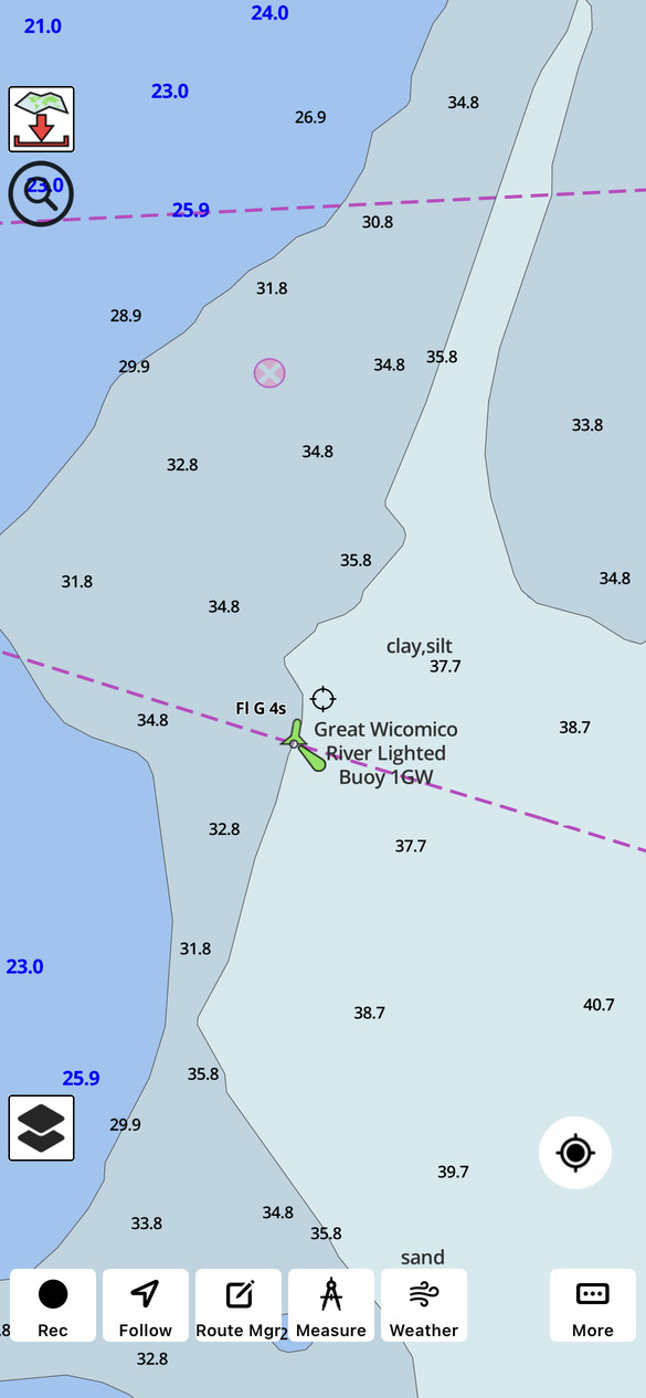
Before and After: Magnified Nautical Chart Labels
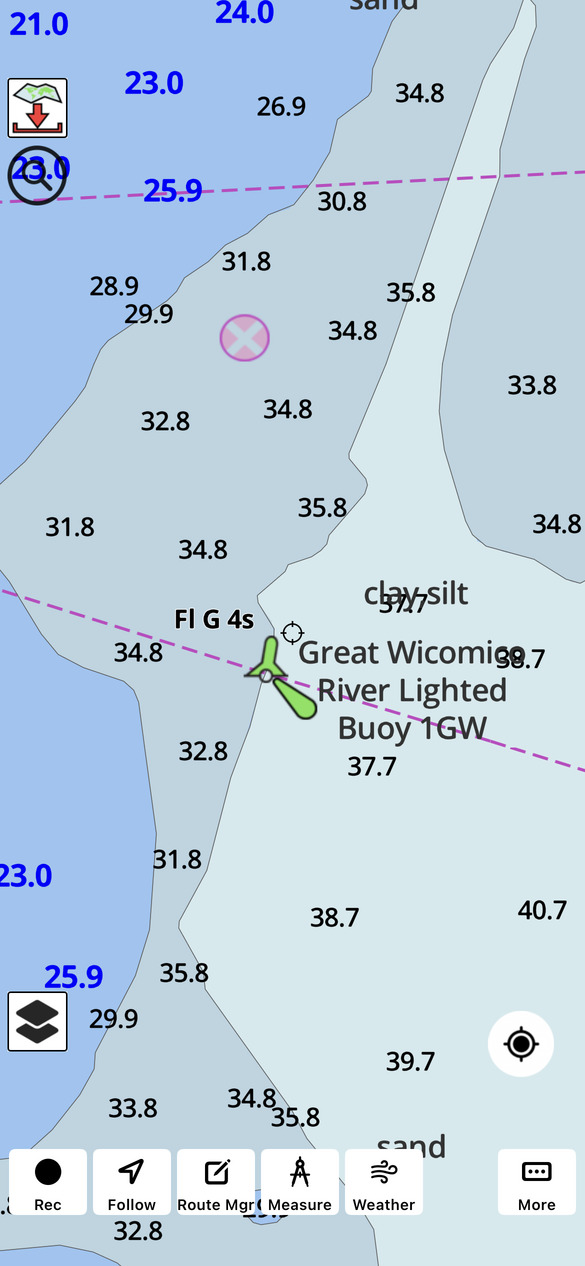
The following screenshots compare the same nautical chart with magnification disabled and enabled.
Normal chart display
Magnified text and icons
Notice how the enlarged depth soundings, chart labels, and navigational symbols improve readability while maintaining the same geographical view.
Extra Display Tips for Farsighted Navigation
- Mount Your Device at Comfortable Arm’s Length: Positioning your tablet or phone slightly farther forward on the helm console puts the screen in a much easier focal zone for farsighted eyes than holding a device close to your face.
- Use High-Contrast Daytime Colors: Pair magnified labels with the bright daylight chart palette so dark soundings and magenta buoy markers stand out clearly against shallow-water shading.
Who Can Benefit From This Feature?
Although particularly useful for farsighted boaters and those experiencing age-related changes in near vision, the feature can benefit anyone who finds small chart labels difficult to read.
It can be especially helpful when using smartphones, navigating in bright daylight, or viewing charts from a greater distance.
By making important nautical chart information easier to read, i-Boating helps boaters navigate more comfortably.
Frequently Asked Questions
Does Magnify Text and Icons change the nautical chart scale?
No. The setting enlarges chart labels and symbols without changing the geographical scale of the nautical chart.
Is this feature useful for boaters with presbyopia?
Yes. Presbyopia is an age-related condition that makes focusing on nearby objects more difficult. Enlarging chart labels can improve readability for users experiencing these changes.
How is magnifying chart text different from zooming in?
Zooming changes the geographical area displayed on the screen. Magnifying text and icons enlarges chart labels and symbols while maintaining the same map scale.