Aspen fishing map is included in Sweden - Stockholm Lakes nautical charts folio. It is available as part of iBoating : Inland Europe Marine & Fishing App (now supported on multiple platforms including Android, iPhone/iPad, MacBook, and Windows(tablet and phone)/PC based chartplotter. ).
With our Lake Maps App, you get all the great marine chart app features like fishing spots, along with Aspen lake depth map. The fishing maps app include HD lake depth contours, along with advanced features found in Fish Finder / Gps Chart Plotter systems, turning your device into a Depth Finder. The Aspen Navigation App provides advanced features of a Marine Chartplotter including adjusting water level offset and custom depth shading. Fishing spots and depth contours layers are available in most Lake maps. Lake navigation features include advanced instrumentation to gather wind speed direction, water temperature, water depth, and accurate GPS with AIS receivers(using NMEA over TCP/UDP). Autopilot support can be enabled during ‘Goto WayPoint’ and ‘Route Assistance’.
Have more questions about the Nautical Chart App? Ask us.
Fishing Info for Aspen
Aspen is a lake in Botkyrka Municipality, Stockholm County, Sweden. The lake is crossed by the European route E4/European route E20 and is located about 20 kilometres southwest of Stockholm, the Swedish capital. It has an area of 1 km2. During the Stone Age, Aspen was in the ocean, but was uplifted by the time of the Bronze Age. Bronze Age settlements grew up around the lake and for some thousand years Iron Age farms were around the lake. The area developed during this period. A graveyard from that period is preserved in the area. Skrävsta Ekholmen nature reserve is in the vicinity of the lake with about sixty large oak trees, half of which are centuries old. There are large bats and many other rare animal and plant species. Around the lake is a nature trail at 7½ km length. The path leads through the woods, high above the marsh.
More on Wikipedia...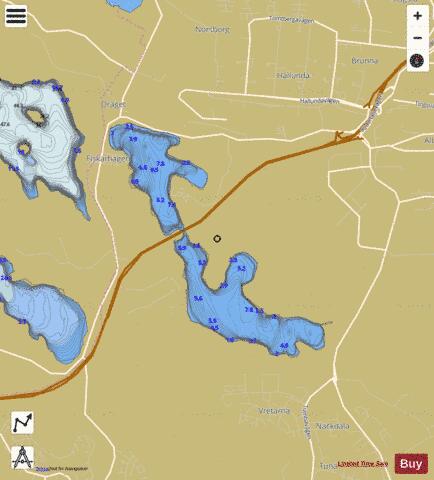
Aspen Fishing Map Stats | |
| Title | Aspen |
| Scale | 1:12000 |
| Area * | 384.56 acres |
| Shoreline * | 7.08 miles |
| Min Longitude | 17.78 |
| Min Latitude | 59.22 |
| Max Longitude | 17.83 |
| Max Latitude | 59.24 |
| Edition Label 1 | |
| Edition Label 2 | |
| Edition Label 3 | |
| Id | II_SE_656832_161545_se |
| Country | Inland Europe |
| Projection | Mercator |
| * some Stats may include nearby/connecting waterbodies | |
|