Lake Trasimeno fishing map is included in Italy - Perugia Lakes nautical charts folio. It is available as part of iBoating : Inland Europe Marine & Fishing App (now supported on multiple platforms including Android, iPhone/iPad, MacBook, and Windows(tablet and phone)/PC based chartplotter. ).
With our Lake Maps App, you get all the great marine chart app features like fishing spots, along with Lake Trasimeno depth map. The fishing maps app include HD lake depth contours, along with advanced features found in Fish Finder / Gps Chart Plotter systems, turning your device into a Depth Finder. The Lake Trasimeno Navigation App provides advanced features of a Marine Chartplotter including adjusting water level offset and custom depth shading. Fishing spots and depth contours layers are available in most Lake maps. Lake navigation features include advanced instrumentation to gather wind speed direction, water temperature, water depth, and accurate GPS with AIS receivers(using NMEA over TCP/UDP). Autopilot support can be enabled during ‘Goto WayPoint’ and ‘Route Assistance’.
Have more questions about the Nautical Chart App? Ask us.
Fishing Info for Lake Trasimeno
Lake Trasimeno (/ˌtrɑːzɪˈmeɪnoʊ/ TRAH-zim-AY-noh, also US: /-ˈmiːnoʊ, ˌtræz-/ -EE-, TRAZ-im-; Italian: Lago Trasimeno [ˈlaːɡo traziˈmɛːno]; Latin: Trasumennus; Etruscan: Tarśmina), also referred to as Trasimene (/ˈtræzɪmiːn/ TRAZ-im-een) or Thrasimene in English, is a lake in the province of Perugia, in the Umbria region of Italy on the border with Tuscany. The lake is south of the river Po and north of the nearby river Tiber and has a surface area of 128 km2 (49.4 sq mi), making it the fourth largest in Italy, slightly smaller than Lake Como. Only two minor streams flow directly into the Lake and none flows out. The water level of the lake fluctuates significantly according to rainfall levels and the seasonal demands from the towns, villages and farms near the shore.
More on Wikipedia...Popular fish species in this lake include Black bullhead, Goldfish and Stone moroko.
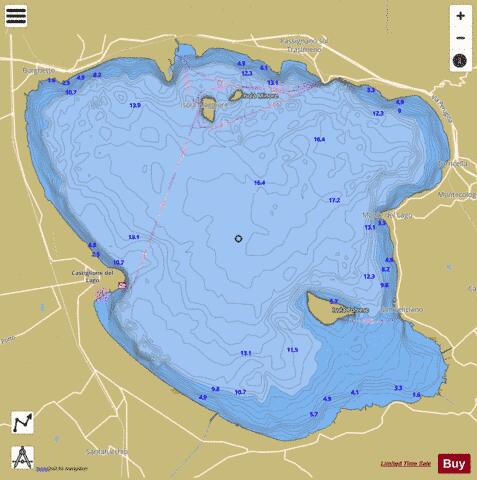
Lake Trasimeno Fishing Map Stats | |
| Title | Lake Trasimeno |
| Scale | 1:24000 |
| Area * | 29654.95 acres |
| Shoreline * | 43.73 miles |
| Min Longitude | 12.02 |
| Min Latitude | 43.08 |
| Max Longitude | 12.19 |
| Max Latitude | 43.20 |
| Edition Label 1 | |
| Edition Label 2 | |
| Edition Label 3 | |
| Id | II_IT_lake_trasimeno_it |
| Country | Inland Europe |
| Projection | Mercator |
| * some Stats may include nearby/connecting waterbodies | |
|