Lake Garda fishing map is included in Italy - Brescia Lakes nautical charts folio. It is available as part of iBoating : Inland Europe Marine & Fishing App (now supported on multiple platforms including Android, iPhone/iPad, MacBook, and Windows(tablet and phone)/PC based chartplotter. ).
With our Lake Maps App, you get all the great marine chart app features like fishing spots, along with Lake Garda depth map. The fishing maps app include HD lake depth contours, along with advanced features found in Fish Finder / Gps Chart Plotter systems, turning your device into a Depth Finder. The Lake Garda Navigation App provides advanced features of a Marine Chartplotter including adjusting water level offset and custom depth shading. Fishing spots and depth contours layers are available in most Lake maps. Lake navigation features include advanced instrumentation to gather wind speed direction, water temperature, water depth, and accurate GPS with AIS receivers(using NMEA over TCP/UDP). Autopilot support can be enabled during ‘Goto WayPoint’ and ‘Route Assistance’.
Have more questions about the Nautical Chart App? Ask us.
Fishing Info for Lake Garda
Lake Garda (Italian: Lago di Garda [ˈlaːɡo di ˈɡarda] or (Lago) Benaco [beˈnaːko]; Eastern Lombard: Lach de Garda; Venetian: Ƚago de Garda; Latin: Benacus; Ancient Greek: Βήνακος) is the largest lake in Italy.It is a popular holiday location in northern Italy, about halfway between Brescia and Verona, and between Venice and Milan on the edge of the Dolomites. Glaciers formed this alpine region at the end of the last ice age. The lake and its shoreline are divided between the provinces of Brescia (to the south-west), Verona (south-east) and Trentino (north).
More on Wikipedia...Popular fish species in this lake include Salmo carpio.
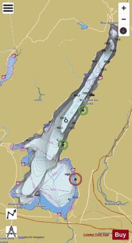
Lake Garda Fishing Map Stats | |
| Title | Lake Garda |
| Sailing Clubs in this Chart region | |
| Vela Garda Trentino | |
| Scale | 1:24000 |
| Area * | 90733.14 acres |
| Shoreline * | 116.96 miles |
| Min Longitude | 10.51 |
| Min Latitude | 45.44 |
| Max Longitude | 10.88 |
| Max Latitude | 45.88 |
| Edition Label 1 | |
| Edition Label 2 | |
| Edition Label 3 | |
| Id | II_IT_lake_garda_it |
| Country | Inland Europe |
| Projection | Mercator |
| * some Stats may include nearby/connecting waterbodies | |
|