LAC DU BOUCHET fishing map is included in France - Haute-Loire Lacs nautical charts folio. It is available as part of iBoating : Inland Europe Marine & Fishing App (now supported on multiple platforms including Android, iPhone/iPad, MacBook, and Windows(tablet and phone)/PC based chartplotter. ).
With our Lake Maps App, you get all the great marine chart app features like fishing spots, along with LAC DU BOUCHET depth map. The fishing maps app include HD lake depth contours, along with advanced features found in Fish Finder / Gps Chart Plotter systems, turning your device into a Depth Finder. The LAC DU BOUCHET Navigation App provides advanced features of a Marine Chartplotter including adjusting water level offset and custom depth shading. Fishing spots and depth contours layers are available in most Lake maps. Lake navigation features include advanced instrumentation to gather wind speed direction, water temperature, water depth, and accurate GPS with AIS receivers(using NMEA over TCP/UDP). Autopilot support can be enabled during ‘Goto WayPoint’ and ‘Route Assistance’.
Have more questions about the Nautical Chart App? Ask us.
Fishing Info for LAC DU BOUCHET
Bouchet lake (or Lake of Bouchet; French: Lac du Bouchet) is located in Haute-Loire, France next to Le Puy-en-Velay. It is about 1.6 km (one mile) north of the village of Le Bouchet-Saint-Nicolas. It is located on the territory of the communes of Cayres and Le Bouchet-Saint-Nicolas Bouchet is a crater lake formed from an old volcano, and thus roughly circular. It is a little more than half a mile from rim to rim and surrounded by woodlands. It is at an altitude of 1,208 m (3,963 feet).
More on Wikipedia...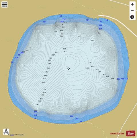
LAC DU BOUCHET Fishing Map Stats | |
| Title | LAC DU BOUCHET |
| Scale | 1:6000 |
| Area * | 108.56 acres |
| Shoreline * | 1.50 miles |
| Min Longitude | 3.79 |
| Min Latitude | 44.91 |
| Max Longitude | 3.80 |
| Max Latitude | 44.91 |
| Edition Label 1 | |
| Edition Label 2 | |
| Edition Label 3 | |
| Id | II_FR_K0129003 |
| Country | Inland Europe |
| Projection | Mercator |
| * some Stats may include nearby/connecting waterbodies | |
|