Mégantic, Lac fishing map is included in Quebec to Anticosti Island West nautical charts folio. It is available as part of iBoating : Canada Marine & Fishing App (now supported on multiple platforms including Android, iPhone/iPad, MacBook, and Windows(tablet and phone)/PC based chartplotter. ).
With our Lake Maps App, you get all the great marine chart app features like fishing spots, along with Mégantic, Lac depth map. The fishing maps app include HD lake depth contours, along with advanced features found in Fish Finder / Gps Chart Plotter systems, turning your device into a Depth Finder. The Mégantic, Lac Navigation App provides advanced features of a Marine Chartplotter including adjusting water level offset and custom depth shading. Fishing spots and depth contours layers are available in most Lake maps. Lake navigation features include advanced instrumentation to gather wind speed direction, water temperature, water depth, and accurate GPS with AIS receivers(using NMEA over TCP/UDP). Autopilot support can be enabled during ‘Goto WayPoint’ and ‘Route Assistance’.
Now i-Boating supports Fishing Points in Mégantic, Lac.
Have more questions about the Nautical Chart App? Ask us.
Fishing Info for Mégantic, Lac
Lake Mégantic (French: Lac Mégantic, French pronunciation: [lak meɡɑ̃tik]) is a body of water in Québec, located in the Appalachian Mountains near the U.S. border. It is a source of the Chaudière River which drains into the St Lawrence River at Québec City. The lake has a surface area of 26.4 km2 (10.2 sq mi) with several villages and small towns on its shores, including Lac-Mégantic, Frontenac, Marston, and Piopolis. It is part of Le Granit Regional County Municipality, a rural region where forestry and granite extraction are important activities.
More on Wikipedia...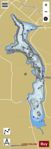
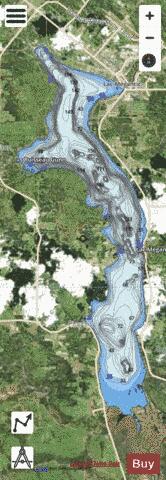
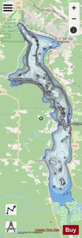
Mégantic, Lac Fishing Map Stats | |
| Title | Mégantic, Lac |
| Scale | 1:24000 |
| Districts | Le Granit |
| Nearby Cities | Lac-Mégantic, Saint-Gédéon, Saint-Martin, Saint-Éphrem-de-Tring, Disraeli, Saint-Georges, Linière, Black Lake, Thetford Mines, Beauceville |
| Area * | 6778.80 acres |
| Shoreline * | 35.13 miles |
| Min Longitude | -70.94 |
| Min Latitude | 45.45 |
| Max Longitude | -70.87 |
| Max Latitude | 45.59 |
| Edition Label 1 | |
| Edition Label 2 | |
| Edition Label 3 | |
| Id | CA_QC_V_01522 |
| Country | CA |
| Projection | Mercator |
| * some Stats may include nearby/connecting waterbodies | |
| |||||||||||||||||||||||||||||||||||||||||||||||||||||||||||||||||||||||||||||||||||||||||||||||||||||||
|