Anchor Alarm Guide: How It Works, Safe Radius Calculation & Setup
Why do Anchors drag and what are the risks?
How to determine the safe radius?
Why is the safe radius so important?
Approach 1: Conservative Method (Recommended for Simplicity)
Approach 2: Geometric Method (More Precise)
How to Calculate Anchor Rode Length
Recommended Anchor Scope Ratios
Example: Calculating the Anchor Alarm Radius
How to set anchor alarm in the i-Boating app
Set anchor alarm at current position
Set anchor at a specific location/waypoint
How to disable/exit Anchor Alarm
Anchor alarm in action: Understanding the display
Frequently Asked Questions About Anchor Alarms
Does an anchor alarm work without an internet connection?
Can an anchor alarm detect when an anchor is dragging?
What is a good anchor alarm radius?
Can I use an external GPS receiver with the i-Boating anchor alarm?
Does an anchor alarm work when the boat swings with the wind or tide?
Does an anchor alarm drain the phone's battery?
Can I use an anchor alarm while sleeping?
What should I do if my anchor alarm sounds?
What is an Anchor Alarm?
An anchor alarm is a critical safety feature in GPS based marine navigational chart apps. It monitors a vessel's position relative to where its anchor was set, sounding an alert if the boat drifts beyond a designated safe zone (radius).
Why do Anchors drag and what are the risks?
Anchors drag due to wind shifts, changing tides, current reversals, or poor bottom holding (e.g., mud vs. rock). This poses a danger as Unchecked dragging leads to grounding, collision with other anchored vessels, or drifting into open water while the crew sleeps.
A digital anchor alarm acts as an extra set of eyes overnight, triggering audible and visual warnings the moment a threshold is crossed.
How do anchor alarms work?
GPS anchor alarms typically establish a virtual boundary (geofence) around a designated reference position. Ideally, this reference position is the actual anchor location. Some applications instead use the boat's GPS position when the alarm is activated. If the reference position differs from the actual anchor location, the alarm radius must account for that difference.
How to determine the safe radius?
Why is the safe radius so important?
Setting the correct anchor alarm radius requires balancing two risks:
- Radius Too Small: Normal swinging of the boat around its anchor causes middle-of-the-night false alarms.
- Radius Too Large: The boat could drag a significant distance toward shallow water before the alarm sounds.
There are two common approaches to calculating the anchor alarm radius: a conservative approach based on the total anchor rode length and a more precise approach based on the horizontal swing distance.
Approach 1: Conservative Method (Recommended for Simplicity)
The simplest approach is to calculate the alarm radius using the total length of anchor rode deployed.
Safe Radius = Rode Length + Vessel Length + GPS Error Margin
Where:
- Rode Length: Total length of anchor chain and/or rope deployed.
- Vessel Length: Length of the boat, providing an additional allowance for its movement around the anchor.
- GPS Error Margin: Additional distance to account for GPS positioning inaccuracies.
This method deliberately overestimates the boat's possible swing radius. It is easy to calculate and reduces false alarms caused by normal swinging.
However, the larger radius may delay detection of anchor dragging, particularly in crowded anchorages or near shallow water.
Approach 2: Geometric Method (More Precise)
A more precise approach calculates the maximum horizontal distance the boat can move from the anchor.
Assuming the anchor rode is fully extended in a straight line:
Horizontal Rode Distance = √(Rode Length² − Vertical Height²)
Where:
- Rode Length: Total length of deployed anchor rode.
- Vertical Height: Distance from the seabed to the bow roller, including tidal height.
The alarm radius can then be estimated as:
Safe Radius = Horizontal Rode Distance + GPS Antenna Offset + GPS Error Margin
GPS Antenna Offset is the horizontal distance between the bow roller and the GPS receiver. Adding this distance provides a conservative estimate of the maximum distance between the anchor and the GPS receiver. Using the full vessel length instead provides a more conservative allowance.
This method produces a tighter boundary than the conservative approach, allowing earlier detection of potential anchor dragging.
Both methods assume the alarm is centered on the actual anchor position. If the alarm is centered on the boat's GPS position instead, the calculation must account for that difference.
How to Calculate Anchor Rode Length
Before calculating the anchor alarm radius, determine how much anchor rode should be deployed.
Anchor scope is the ratio of deployed rode length to the vertical distance from the seabed to the vessel's bow roller.
Rode Length = Scope Ratio × (Water Depth + Bow Height Above Waterline)
For tidal waters, use the expected water depth at high tide:
Water Depth at High Tide = Charted Depth + Tide Height Above Chart Datum
This assumes the charted depth and tide prediction use the same vertical datum. Chart datum is often near a low-water reference, but the exact datum varies by region.
Recommended Anchor Scope Ratios
The following ratios are general starting points, not universal requirements.
|
Rode Type |
Conditions |
Typical Scope |
|
All-chain |
Mild conditions |
3:1 to 4:1 |
|
All-chain |
Moderate to strong wind |
5:1 to 7:1 |
|
Rope/chain combination |
Standard overnight anchoring |
5:1 to 7:1 |
|
Rope/chain combination |
Strong wind or storms |
7:1 to 10:1 |
Actual scope requirements depend on anchor design, seabed holding conditions, vessel characteristics, wind, currents, and manufacturer recommendations. Longer scope generally improves holding geometry but also increases the area required for the boat to swing.
Example: Calculating the Anchor Alarm Radius
Consider a boat anchored under the following conditions:
- Charted water depth: 15 feet
- Expected tide height: 3 feet
- Bow roller height above water: 2 feet
- Desired scope ratio: 5:1
- Vessel length: 30 feet
- GPS error margin: 15 feet
Step 1: Calculate vertical height
Vertical Height = 15 + 3 + 2 = 20 feet
Step 2: Calculate rode length
Rode Length = 5 × 20 = 100 feet
Step 3: Calculate the conservative alarm radius
Safe Radius = 100 + 30 + 15 = 145 feet
Step 4: Calculate the geometric alarm radius
Horizontal Rode Distance = √(100² − 20²) = 98 feet
Assuming the GPS receiver is 20 feet behind the bow roller:
Safe Radius = 98 + 20 + 15 = 133 feet
In this example, the conservative method produces a radius of 145 feet, while the geometric method produces 133 feet.
The geometric calculation is still an approximation because actual rode geometry, chain catenary, GPS movement, and boat orientation can vary.
Which Method Should You Use?
For recreational boaters, the conservative method provides a simple starting point and helps avoid nuisance alarms.
However, a smaller, carefully calculated radius may be preferable when anchored near other boats, shorelines, or shallow water, where early detection of dragging is particularly important.
Regardless of the method, verify that the selected radius fits within the available safe water around the anchorage. If the boat cannot swing safely within the required area, choose a different anchoring location rather than simply reducing the alarm radius.
An anchor alarm should always supplement proper anchoring techniques and regular monitoring, not replace them.
How to set anchor alarm in the i-Boating app
Set anchor alarm at current position
Tap more button and select “Set Anchor”. This sets anchor at the current location using the anchor radius defined under settings.
Set anchor at a specific location/waypoint
- Tap on the info button next to the waypoint
- Select “Set Anchor”. This would set anchor at the selected way point.
Updating anchor radius
- Tap more button and select “Settings”
- Scroll down and change the anchor alarm radius
- Tap Save
How to disable/exit Anchor Alarm
When the anchor alarm is enabled, there should be an “Exit” button on the screen to disable the anchor alarm as well.
Anchor alarm in action: Understanding the display
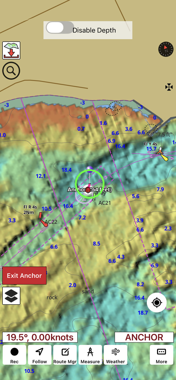
Here is a screenshot of the app with anchor alarm in action.
- The purple pin shows where the anchor is set.
- The green circle shows the geofence. The label “164 ft” refers to the geofence radius.
- The pink/magenta line shows the distance between the anchor's designated position and the boat's current GPS position. This distance can change as the boat swings naturally around its anchor and does not necessarily indicate anchor dragging.
- The red dot shows the current position of the boat.
Frequently Asked Questions About Anchor Alarms
Does an anchor alarm work without an internet connection?
Yes. The i-Boating anchor alarm works without an internet connection, provided the device has a built-in GPS receiver capable of obtaining its location directly from GPS satellites.
GPS positioning does not require cellular data, Wi-Fi, or an internet connection. However, not all smartphones and tablets have built-in GPS receivers.
The i-Boating app can also receive GPS position data from an external GPS device using NMEA data streams transmitted over TCP or UDP.
Can an anchor alarm detect when an anchor is dragging?
An anchor alarm does not directly detect movement of the anchor itself. Instead, it monitors the boat's GPS position relative to a designated anchor location.
If the boat moves beyond the configured alarm radius, the alarm is triggered. This may indicate anchor dragging, but GPS inaccuracies or an incorrectly configured radius can also cause alarms.
What is a good anchor alarm radius?
The appropriate radius depends on the length of anchor rode deployed, water depth, vessel size, GPS accuracy, and available swinging room.
A conservative starting point is:
Anchor Alarm Radius = Rode Length + Vessel Length + GPS Error Margin
This allows for normal swinging around the anchor. However, in crowded anchorages or near shallow water, a more precise radius may provide earlier warning of anchor dragging.
Can I use an external GPS receiver with the i-Boating anchor alarm?
Yes. In addition to built-in GPS receivers, i-Boating supports GPS position data received through NMEA streams over TCP or UDP.
This allows compatible external GPS receivers and marine navigation equipment to provide location information to the application.
The external GPS source must remain connected and provide valid position updates for the anchor alarm to function reliably.
Does an anchor alarm work when the boat swings with the wind or tide?
Yes. An anchor alarm is designed to accommodate normal movement of a boat around its anchor.
As wind and current change, the boat may swing in different directions without dragging its anchor. As long as the boat's GPS position remains within the configured alarm boundary, the alarm will not trigger.
Does an anchor alarm drain the phone's battery?
An anchor alarm requires continuous GPS position monitoring, which consumes battery power.
For overnight anchoring, keeping the device connected to a reliable power source is recommended. Also ensure that device power-management settings do not interrupt GPS updates or prevent the application from sounding an alarm.
Can I use an anchor alarm while sleeping?
Yes. Anchor alarms are particularly useful during overnight anchoring because they can alert boaters to unexpected vessel movement.
However, an anchor alarm should not be the sole means of monitoring the vessel. Ensure that the alarm is audible, the device has sufficient power, and GPS positioning remains available throughout the night.
What should I do if my anchor alarm sounds?
First, check the vessel's current position and surroundings. Determine whether the movement is caused by normal swinging, GPS inaccuracies, or actual anchor dragging.
If the anchor is dragging, take immediate action to prevent grounding or collision. Depending on the circumstances, this may involve starting the engine, resetting the anchor, or moving to a safer anchorage.
Never dismiss an anchor alarm without checking the vessel's position.